
International
ADVANCED AND APPLIED SCIENCES
EISSN: 2313-3724, Print ISSN: 2313-626X
Frequency: 12
![]()
Volume 9, Issue 9 (September 2022), Pages: 61-69

----------------------------------------------
Original Research Paper
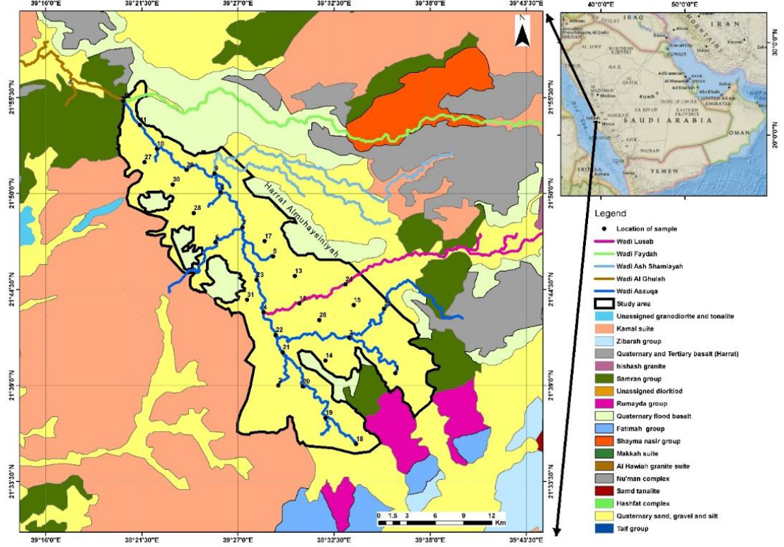
Evaluation of grain size distribution of Wadi As Suqah, Northeast of Jeddah, Saudi Arabia
Author(s): Musaad A. Alotaibi, Mohammed A. M. Alghamdi *
Affiliation(s):
Faculty of Earth Science, King Abdulaziz University, Jeddah, Saudi Arabia

* Corresponding Author.
 Corresponding author's ORCID profile: https://orcid.org/0000-0002-7790-5698
Digital Object Identifier:
https://doi.org/10.21833/ijaas.2022.09.008
Abstract:
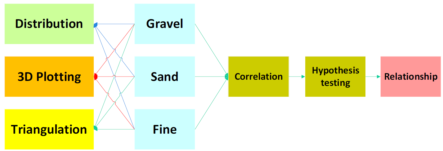
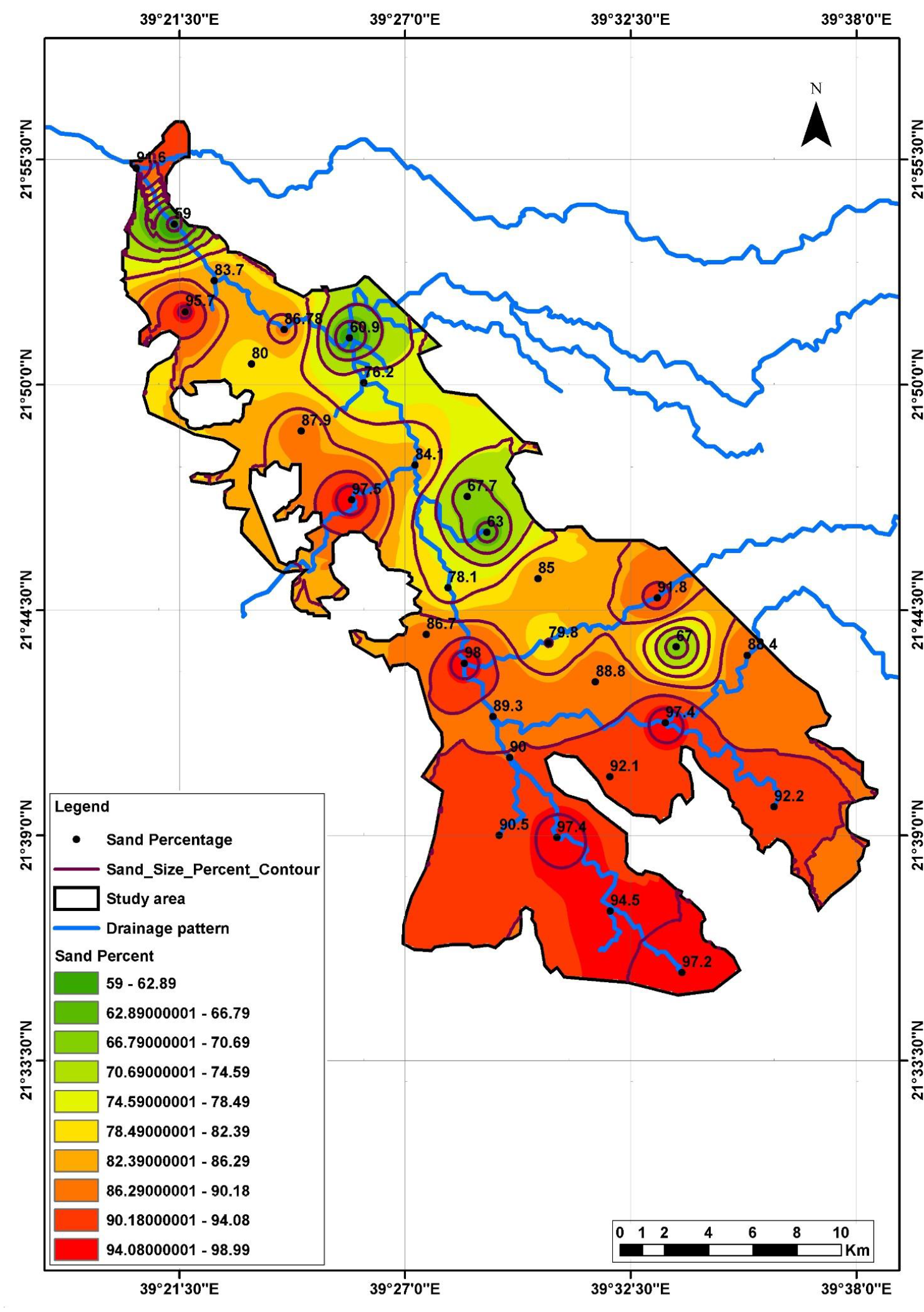
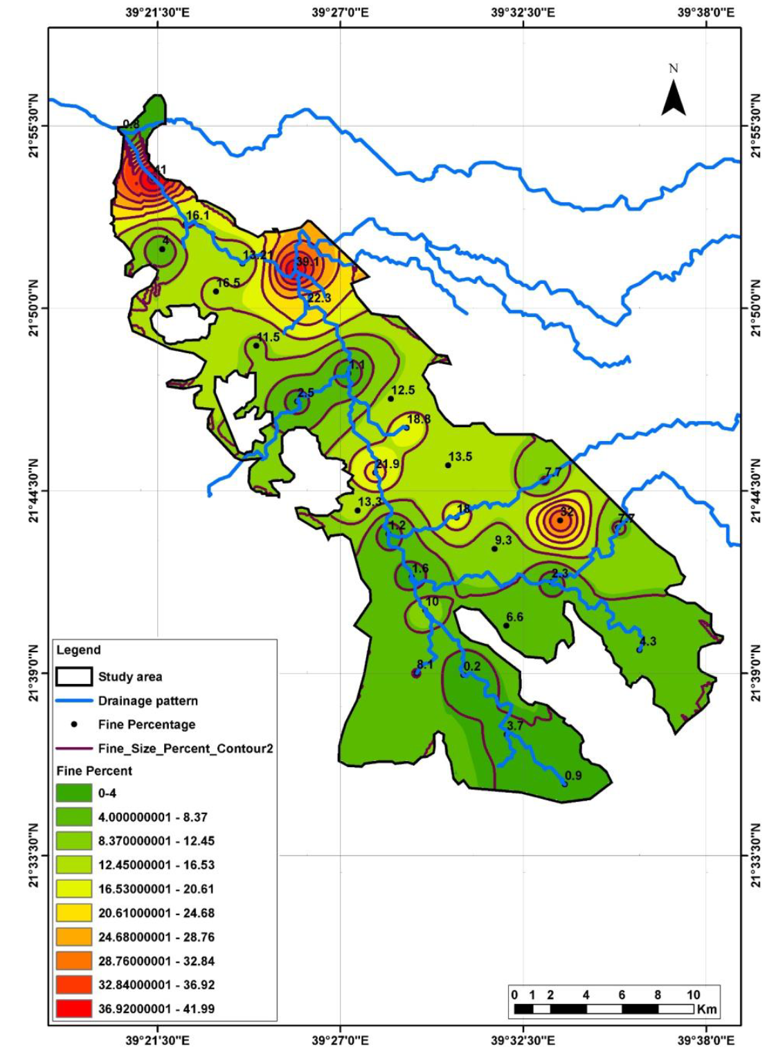
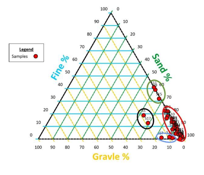
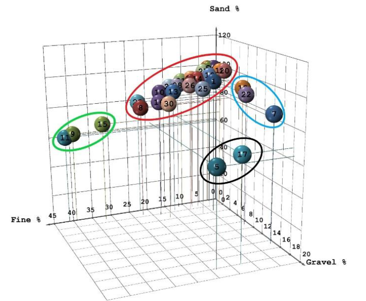
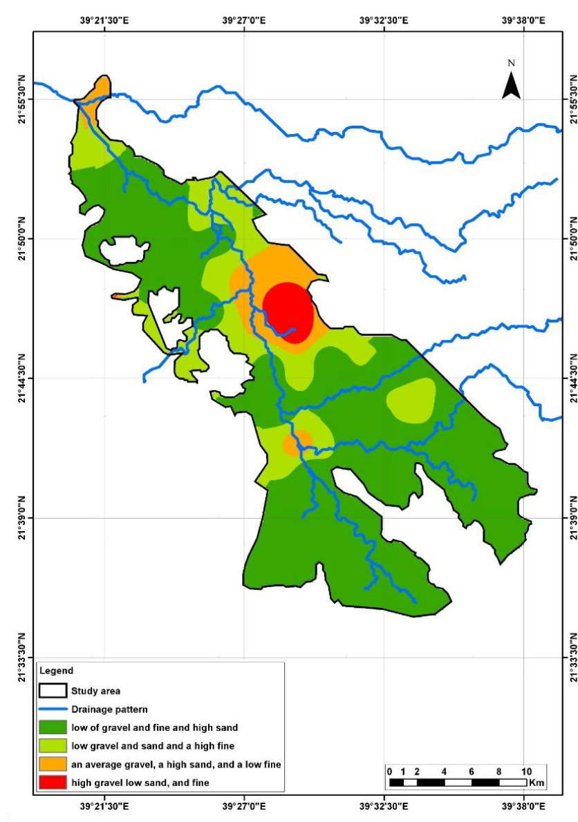
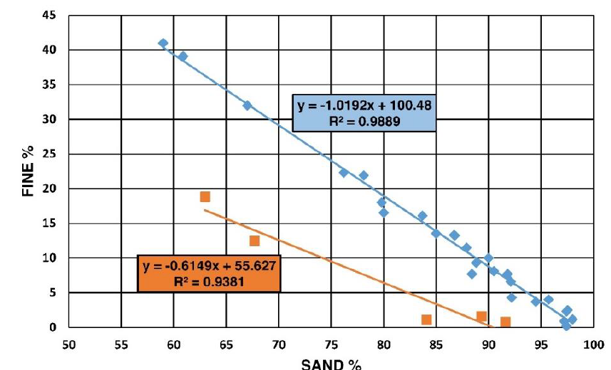
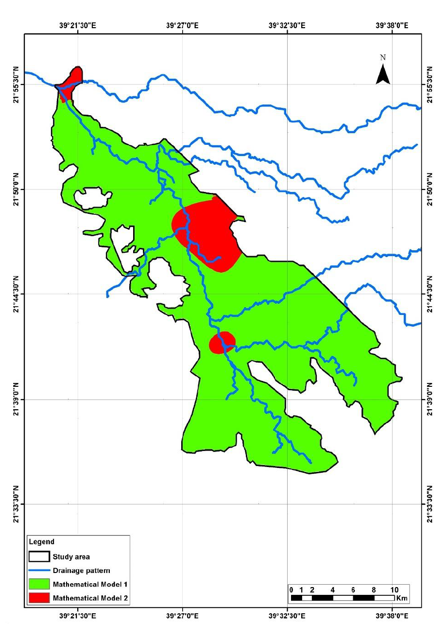
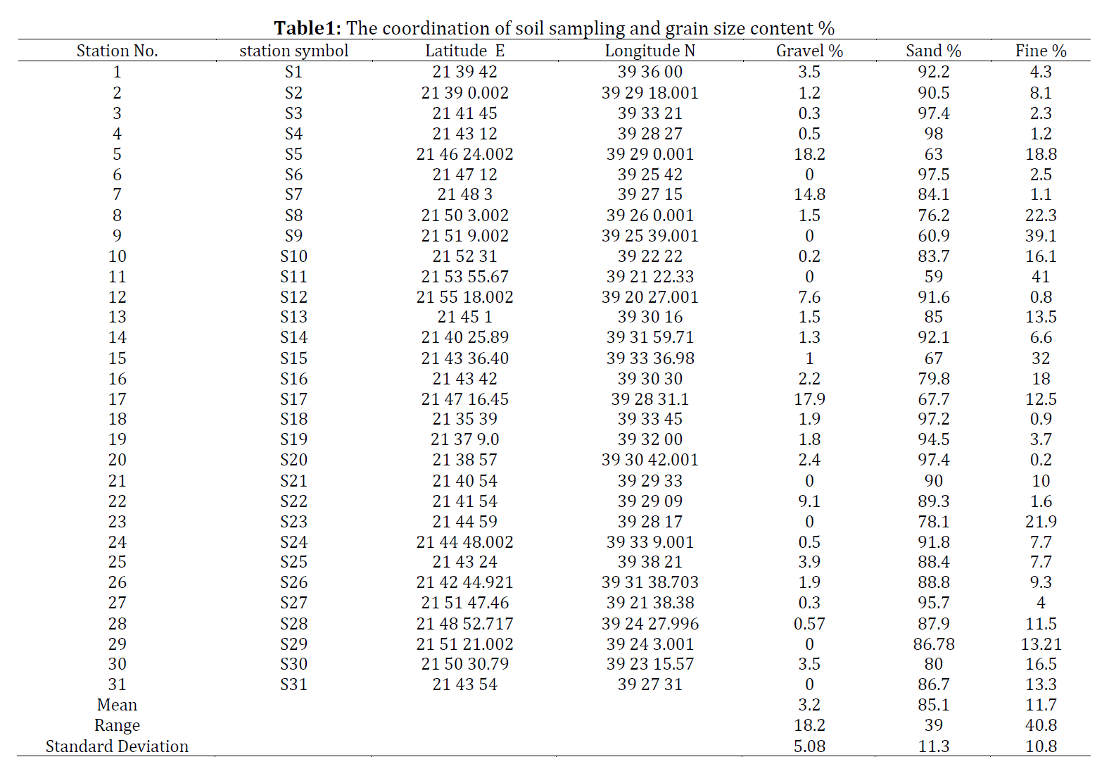
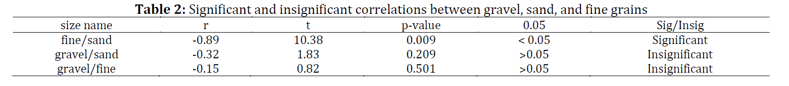
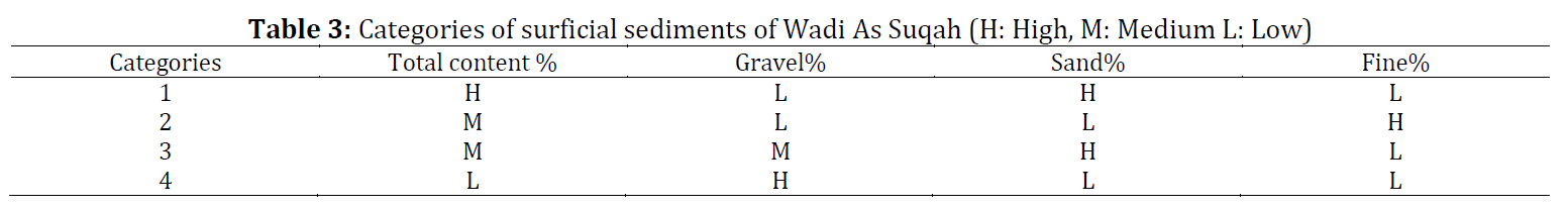
Wadi As Suqah, Makkah Governate, Western Saudi Arabia, has surficial sediments covering 300-422 square kilometers. The deposits may be used for any suitable construction material. Therefore, thirty-one samples of the Quaternary sands were collected from different locations along the study area to achieve this goal. The natural surficial grain sizes of Wadi As Suqah deposits in the Makkah region were assessed geotechnically, spatially, and mathematically. Rarely comprehensive exploration methodology, such as sieve analysis, 3D modeling, triangulation, and GIS, have been used to categorize the content percentage of grain sizes. Statistics and mathematics were also used to evaluate the correlations and assess the relationship between the fractions. This sophisticated approach is adapted for the first time on Wadi As Suqah, which concludes different results compared to previous studies. According to the unified soil classification system, gravel, sand, and fine had an average content of 85.1%, 11.7%, and 3.2%, respectively. Therefore, Wadi As Suqah, based on the fractions percentage, is categorized into four spatially sandy zones. At a coefficient of determination, R²=0.98, sand, and fine have a linear relationship. The major mathematical model is y=-1.02 x+100.5, in which y is the fine % content, and x is the sand % content. It can be merged with mineralogy for future studies to evaluate sediment from a geological engineering point of view.
© 2022 The Authors. Published by IASE.
This is an
Keywords: Gravel, Sand, Fine, Correlation, Relationship
Article History: Received 18 February 2022, Received in revised form 14 May 2022, Accepted 6 June 2022
Acknowledgment
No Acknowledgment.
Compliance with ethical standards
Conflict of interest: The author(s) declared no potential conflicts of interest with respect to the research, authorship, and/or publication of this article.
Citation:
Alotaibi MA and Alghamdi MAM (2022). Evaluation of grain size distribution of Wadi As Suqah, Northeast of Jeddah, Saudi Arabia. International Journal of Advanced and Applied Sciences, 9(9): 61-69
Figures
Fig. 1 Fig. 2 Fig. 3 Fig. 4 Fig. 5 Fig. 6 Fig. 7 Fig. 8 Fig. 9 Fig. 10
Tables
----------------------------------------------
References (12)
- ASTM (2010). Standard practice for classification of soils for engineering purposes (unified soil classification system). ASTM D2487-06, ASTM International, West Conshohocken, USA. https://doi.org/10.1520/D2487-06 [Google Scholar]
- ASTM C (2017). Standard test method for sieve analysis of fine and coarse aggregates. ASTM C136-06, ASTM International, West Conshohocken, USA. https://doi.org/10.1520/C0136-01 [Google Scholar]
- Bailey M (2005). The complete idiot's guide to statistics. Technometrics, 47(4): 524-524. https://doi.org/10.1198/tech.2005.s331 [Google Scholar]
- Blott SJ and Pye K (2001). GRADISTAT: A grain size distribution and statistics package for the analysis of unconsolidated sediments. Earth Surface Processes and Landforms, 26(11): 1237-1248. https://doi.org/10.1002/esp.261 [Google Scholar]
- Bluman AG (2009). Elementary statistics: A step by step approach. McGraw-Hill Higher Education, New York, USA. [Google Scholar]
- EL-Didy SM (1998). Hydrologic calculations in Wadis Hada Al sham and Usfan. Meteorology, Environment and Arid Land Agriculture Sciences, 9(1): 159-177. https://doi.org/10.4197/met.9-1.13 [Google Scholar]
- Handy RL (2007). Geotechnical engineering: Soil and foundation principles and practice. McGraw-Hill Education, New York, USA. [Google Scholar]
- Kotb H, Zaidi SM, and Hakim H (1988). Hydrochemical characteristics of groundwater in the Usfan Basin, Saudi Arabia. Earth Sciences Journal, 1(1): 113-132. https://doi.org/10.4197/Ear.1-1.6 [Google Scholar]
- Moore TA and Al-Rehaili MH (1989). Geologic map of Makkah Quadrangle, Sheet 21D, Kingdom of Saudi Arabia. Deputy Ministry for Mineral Resources Publication, Jeddah, Saudi Arabia. [Google Scholar]
- Murthy VNS (2002). Geotechnical engineering: Principles and practices of soil mechanics and foundation engineering. CRC Press, Boca Raton, USA. [Google Scholar]
- Sharaf MAM (2011). Geological and geophysical exploration of the groundwater aquifers of as Suqah area, Makkah district, Western Arabian Shield, Saudi Arabia. Arabian Journal of Geosciences, 4(5): 993-1004. https://doi.org/10.1007/s12517-010-0187-1 [Google Scholar]
- Spincer CH and Vincent PL (1984). Bentonite resource potential and geology of the Cenozoic sediments. Open-File Report BRGM-OF-02-34, 34, Saudi Arabian Deputy Ministry for Mineral Resources, Jeddah, Saudi Arabia. [Google Scholar]