
International
ADVANCED AND APPLIED SCIENCES
EISSN: 2313-3724, Print ISSN: 2313-626X
Frequency: 12
![]()
Volume 9, Issue 10 (October 2022), Pages: 106-115

----------------------------------------------
Original Research Paper
Managing power infrastructure using LiDAR
Author(s): Vivian Sultan *, Jose Ramirez, Jordan Peabody, Madison Bautista
Affiliation(s):
College of Business and Economics, California State University, Los Angeles, USA

* Corresponding Author.
 Corresponding author's ORCID profile: https://orcid.org/0000-0002-1066-5212
Digital Object Identifier:
https://doi.org/10.21833/ijaas.2022.10.014
Abstract:
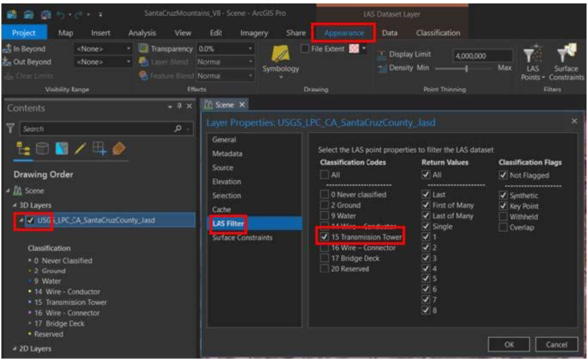
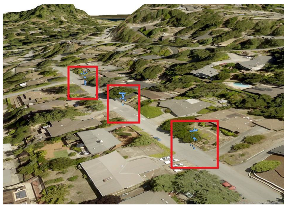
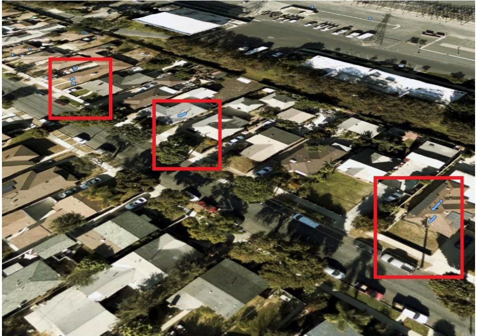
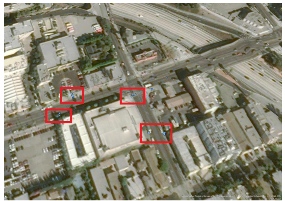
This manuscript empirically focuses on machine learning to identify objects from point-cloud data. The literature suggests deep learning can be used as a tool to classify objects of interest. Researchers in this study used light detection and ranging (LiDAR) point-cloud data to identify power poles and towers. This study sought to demonstrate the use of a deep-learning model developed by a group based in Australia and ESRI to determine whether deep learning is a viable solution for identifying power assets in three California areas. This study instantiated an existing trained model to determine whether deep learning is an effective solution for extracting the desired objects from point-cloud data. The deep-learning model successfully identified power poles in both rural and urban areas. However, the model performance was better in urban areas than in rural areas. This study supports the literature that deep learning can successfully classify point clouds. To improve the model performance and to ensure optimal results when training the model, the authors emphasize the importance of accurately labeled data to represent the objects of interest. To produce the desired results, one should develop one’s own training and validation data.
© 2022 The Authors. Published by IASE.
This is an
Keywords: LiDAR, Deep learning, Point cloud, ArcGIS Pro, Point classification
Article History: Received 24 January 2022, Received in revised form 29 April 2022, Accepted 2 July 2022
Acknowledgment
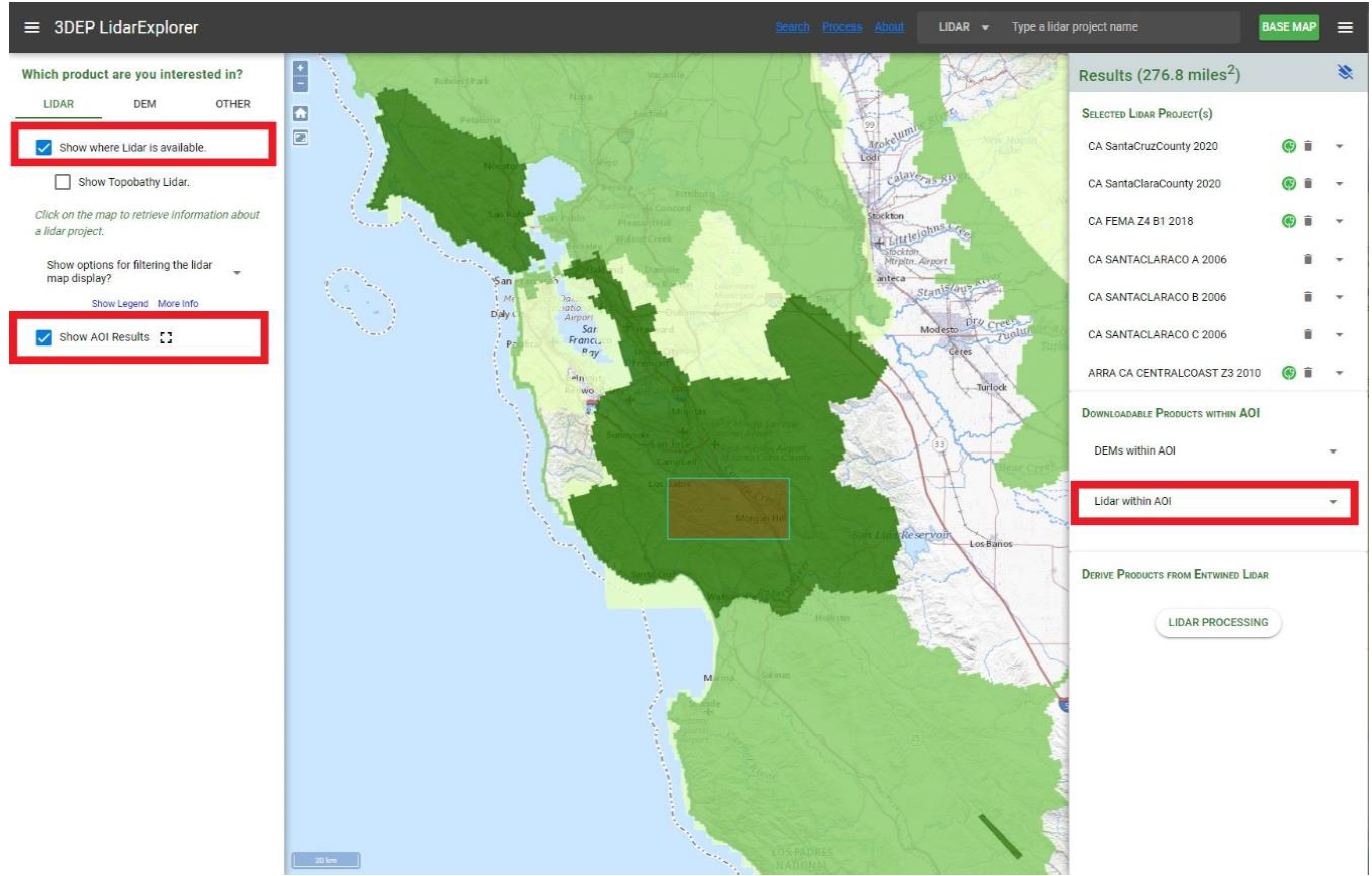
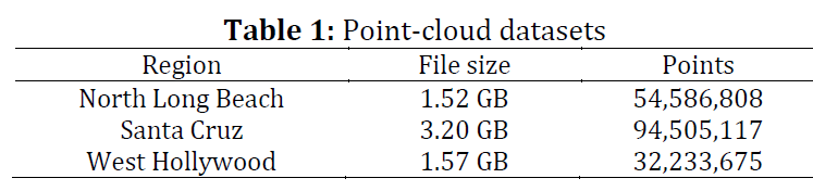
The group would like to acknowledge Professor Vivian Sultan and Teacher Assistant Benjamin Pezzillo for their guidance and contribution to the group research project. Their support (both technical and personal) was a significant factor in our group’s success. On behalf of the group, thank you for your continued support and effort to see this project through to the end. This research is based on students’ course project work at the graduate school, Information Systems department of California State University, Los Angeles. This research received no external funding. This research project used publicly available point-cloud data from the United States Geological Survey website https://prd-tnm.s3.amazonaws.com/LidarExplorer/index.html#/. Point cloud data covering regions in Santa Cruz, West Hollywood, and North Long Beach were downloaded and analyzed.
Compliance with ethical standards
Conflict of interest: The author(s) declared no potential conflicts of interest with respect to the research, authorship, and/or publication of this article.
Citation:
Sultan V, Ramirez J, and Peabody J et al. (2022). Managing power infrastructure using LiDAR. International Journal of Advanced and Applied Sciences, 9(10): 106-115
Figures
Fig. 1 Fig. 2 Fig. 3 Fig. 4 Fig. 5 Fig. 6 Fig. 7 Fig. 8 Fig. 9 Fig. 10 Fig. 11 Fig. 12 Fig. 13 Fig. 14
Tables
----------------------------------------------
References (16)
- Antunes J (2018). Should you choose LiDAR or photogrammetry for aerial drone surveys? Commercial UAV News, Las Vegas, USA.
- Azevedo F, Dias A, Almeida J, Oliveira A, Ferreira A, Santos T, and Silva E (2019). LiDAR-based real-time detection and modeling of power lines for unmanned aerial vehicles. Sensors, 19(8): 1812. https://doi.org/10.3390/s19081812 [Google Scholar] PMid:30995721 PMCid:PMC6515251
- Borcs A, Nagy B, and Benedek C (2017). Instant object detection in LiDAR point clouds. IEEE Geoscience and Remote Sensing Letters, 14(7): 992-996. https://doi.org/10.1109/LGRS.2017.2674799 [Google Scholar]
- Brubaker KM, Myers WL, Drohan PJ, Miller DA, and Boyer EW (2013). The use of LiDAR terrain data in characterizing surface roughness and microtopography. Applied and Environmental Soil Science, 2013: 891534. https://doi.org/10.1155/2013/891534 [Google Scholar]
- Esri (2021a). Classify a point cloud with deep learning. Geographic Information System Company, Redlands, USA. [Google Scholar]
- Esri (2021b). Introduction to deep learning and point clouds. Geographic Information System Company, Redlands, USA. [Google Scholar]
- Fan Y-C, Yelamandala CM, Chen TW, and Huang CJ (2021). Real-time object detection for LiDAR based on LS-R-YOLOv4 neural network. Journal of Sensors, 2021: 5576262. https://doi.org/10.1155/2021/5576262 [Google Scholar]
- Glavinich TE (2021). Pricing service work for profit. Electrical Contractor Magazine, Knoxville, USA. [Google Scholar]
- Kudinov D (2019). PointCNN: Replacing 50,000 man hours with AI. Available online at: https://medium.com/geoai/pointcnn-replacing-50-000-man-hours-with-ai-d7397c1e7ffe
- Maggiori E, Tarabalka Y, Charpiat G, and Alliez P (2016). Convolutional neural networks for large-scale remote-sensing image classification. IEEE Transactions on Geoscience and Remote Sensing, 55(2): 645-657. https://doi.org/10.1109/TGRS.2016.2612821 [Google Scholar]
- Nahhas FH, Shafri HZ, Sameen MI, Pradhan B, and Mansor S (2018). Deep learning approach for building detection using LiDAR–Orthophoto fusion. Journal of Sensors, 2018: 7212307. https://doi.org/10.1155/2018/7212307 [Google Scholar]
- NOAA (2021). What Is LiDAR. National Oceanic and Atmospheric Administration, Washington, USA. [Google Scholar]
- Prokhorov DV (2009). Object recognition in 3D lidar data with recurrent neural network. In the IEEE Computer Society Conference on Computer Vision and Pattern Recognition Workshops, IEEE, Miami, USA: 9-15. https://doi.org/10.1109/CVPRW.2009.5204114 [Google Scholar]
- Singh KK, Chen G, McCarter JB, and Meentemeyer RK (2015). Effects of LiDAR point density and landscape context on estimates of urban forest biomass. ISPRS Journal of Photogrammetry and Remote Sensing, 101: 310-322. https://doi.org/10.1016/j.isprsjprs.2014.12.021 [Google Scholar]
- Van Leeuwen M and Nieuwenhuis M (2010). Retrieval of forest structural parameters using LiDAR remote sensing. European Journal of Forest Research, 129(4): 749-770. https://doi.org/10.1007/s10342-010-0381-4 [Google Scholar]
- Van Tassel C (2021). The true cost-Implementing LiDAR into your business. LiDAR News, New Hampshire, USA. [Google Scholar]