
International
ADVANCED AND APPLIED SCIENCES
EISSN: 2313-3724, Print ISSN: 2313-626X
Frequency: 12
![]()
Volume 8, Issue 12 (December 2021), Pages: 63-79

----------------------------------------------
Original Research Paper
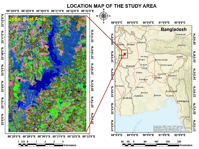
Title: Evaluation of spatiotemporal dynamics of land cover and land surface temperature using spectral indices and supervised classification: A case study of Jobai Beel Area, Bangladesh
Author(s): A. B. M. Abu Haider 1, *, Abd Wahid Bin Rasib 1, Baharin Bin Ahmad 1, Sumaiya Jarin Ahammed 2
Affiliation(s):
1Department of Geoinformation, Faculty of Built Environment and Surveying, University Teknologi Malaysia, Johor Bahru, Malaysia
2Department of Civil Engineering, International University of Business Agriculture and Technology, Dhaka, Bangladesh

* Corresponding Author.
 Corresponding author's ORCID profile: https://orcid.org/0000-0002-2581-2190
Digital Object Identifier:
https://doi.org/10.21833/ijaas.2021.12.009
Abstract:
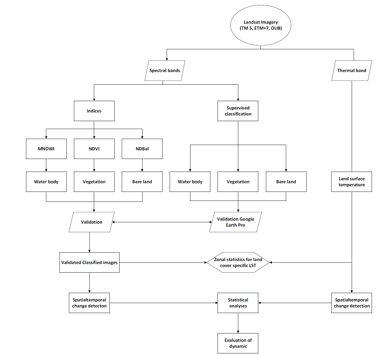
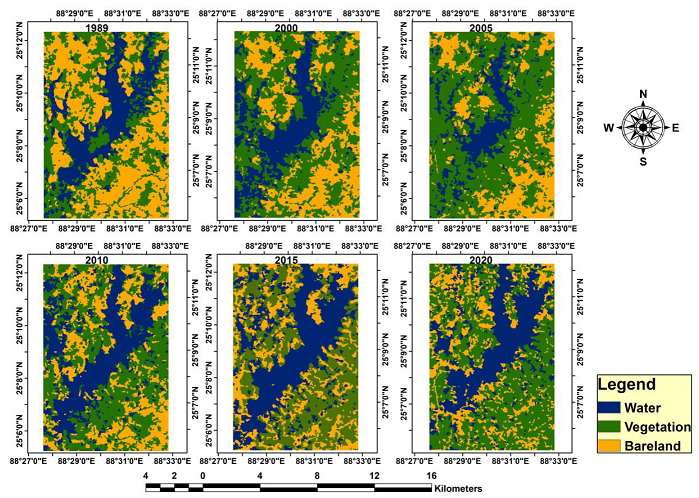
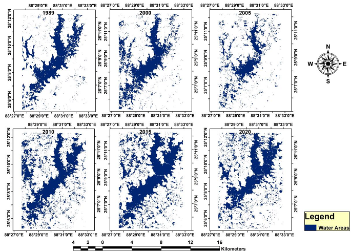
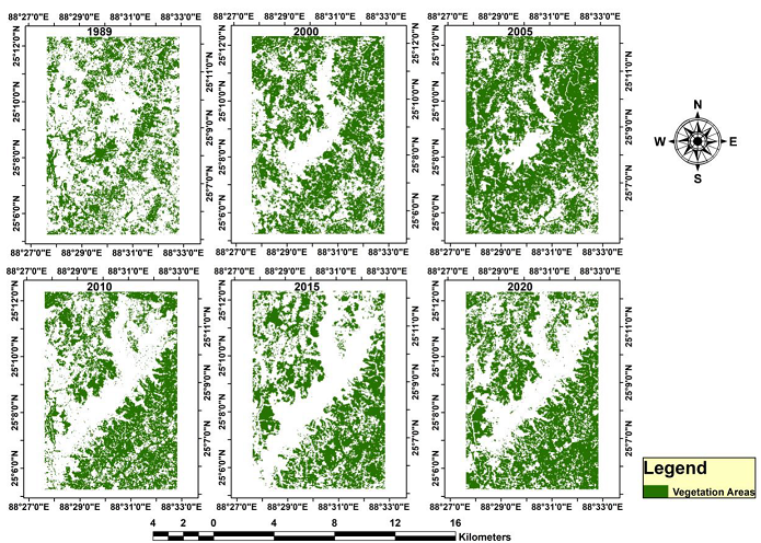
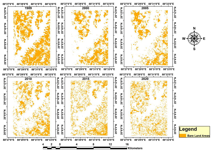
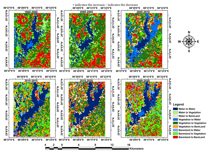
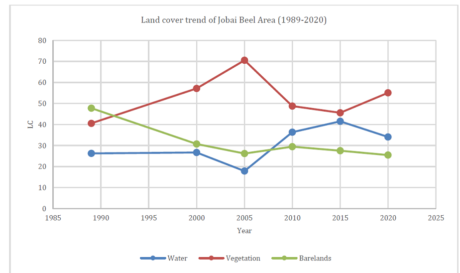
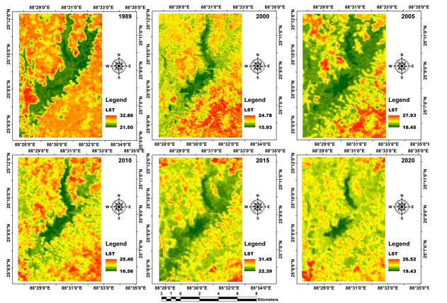
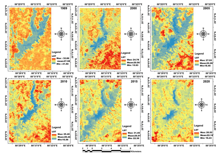
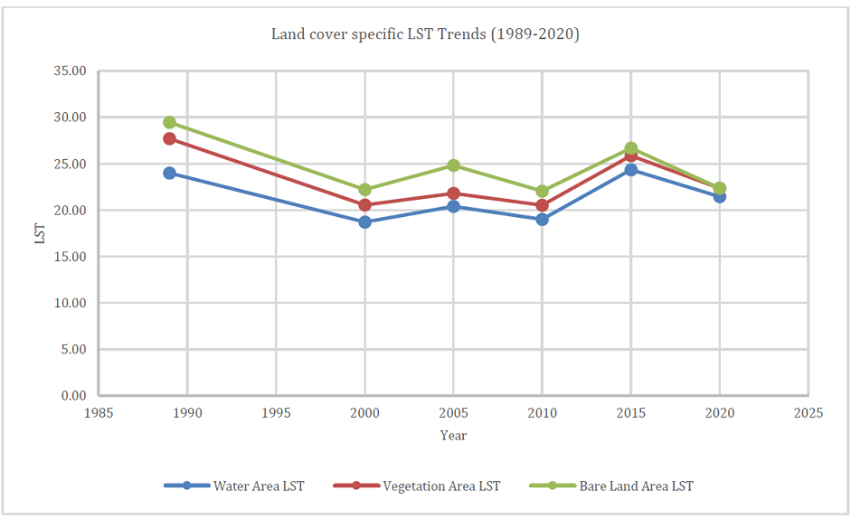
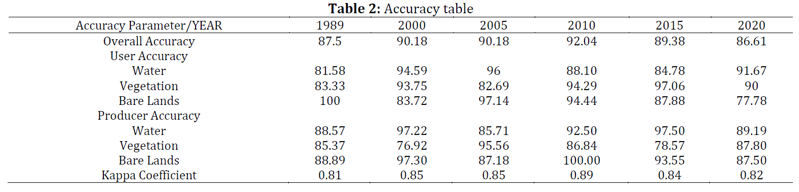
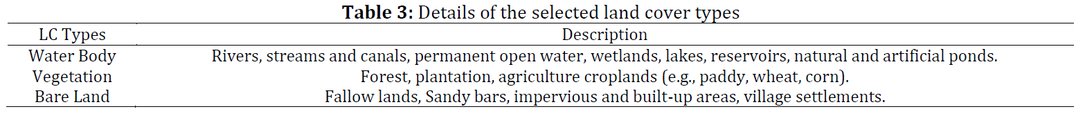
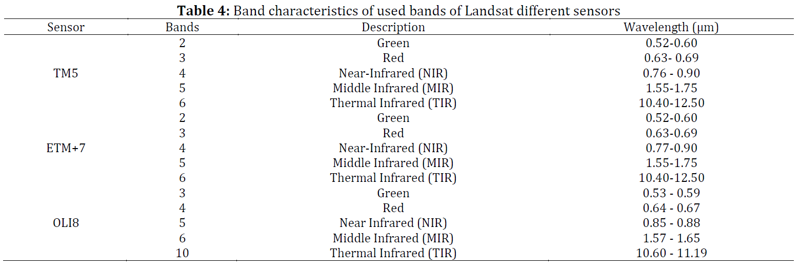
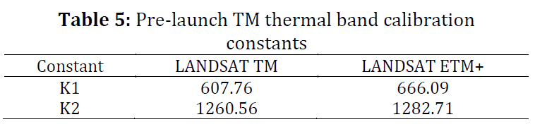
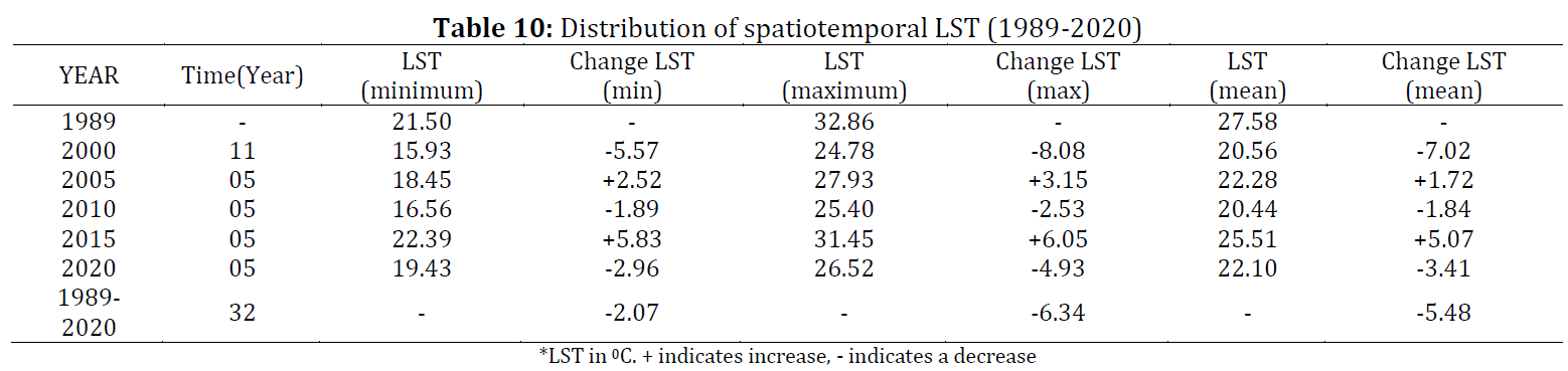
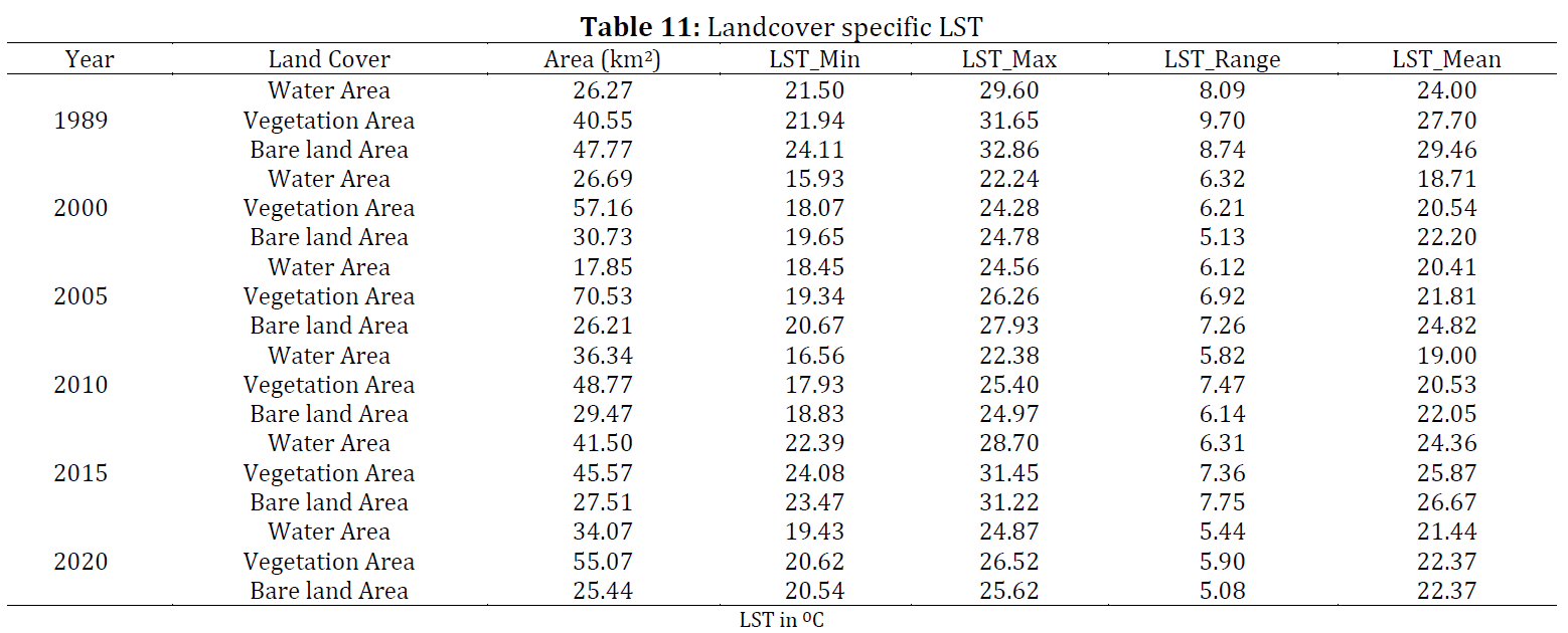
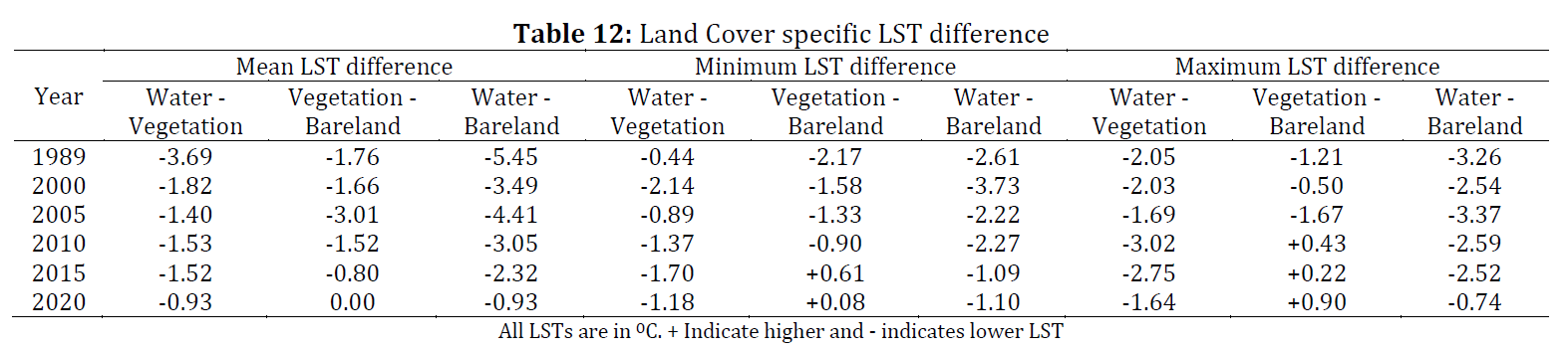
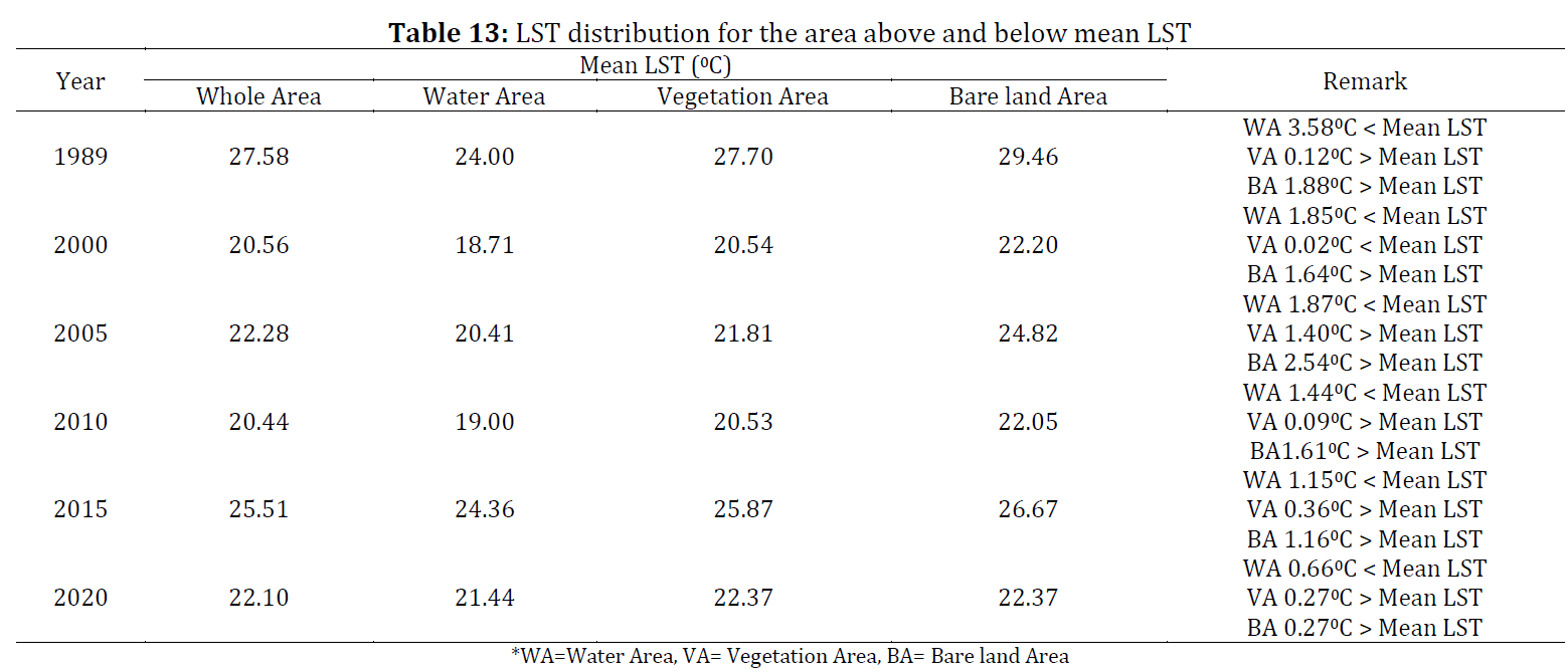
This study aims to evaluate the spatiotemporal change of land cover (LC) and surface temperature of the Jobai Beel area, an exclusive agriculture zone, situated in the far-flung area of northwest Bangladesh using satellite data. Multi-temporal Landsat series of data from 1989 to 2020 and geospatial techniques have been employed to evaluate the LC change and land surface temperature (LST) variation. Different spectral indices such as NDVI, MNDWI, NDBal have been used to retrieve individual LC. Corresponding LST has also been extracted using the thermal bands. Supervised Classification and the post-classification change detection technique were employed to determine the temporal changes and validate the individual LC. The results were employed to assess the LST variation associated with LC changes. The results reveal that the area had undergone a drastic and inconsistent heterogeneous LC transformation during the study period. Water and vegetation areas have expanded at a rate of 0.24km2/year and 0.45km2/year respectively, while bare lands have shrunk at a rate of 0.70km2/year. In general, Bare land exhibits a significant positive correlation, when Vegetation areas show a significant negative correlation with LST. However, the correlation between water areas and LST was found statistically insignificant. Agriculture in the form of vegetation has been found the most dominating land cover character throughout the study period, which has been regulating the LST variation across the area.
© 2021 The Authors. Published by IASE.
This is an
Keywords: MNDWI, NDVI, NDBaI, Land surface temperature, Jobai Beel
Article History: Received 28 May 2021, Received in revised form 11 September 2021, Accepted 6 October 2021
Acknowledgment
The authors would like to express their profound gratitude to the Faculty of Built Environment and Surveying (FABU), Universiti Teknologi Malaysia (UTM), for all the support that has been provided. The authors would also like to address a special thanks to grants awarded under UTM CR DID VOT 4C255 and UTM IIIG VOT 01M78.
Compliance with ethical standards
Conflict of interest: The author(s) declared no potential conflicts of interest with respect to the research, authorship, and/or publication of this article.
Citation:
Abu Haider ABM, Rasib AWB, and Ahmad BB et al. (2021). Evaluation of spatiotemporal dynamics of land cover and land surface temperature using spectral indices and supervised classification: A case study of Jobai Beel Area, Bangladesh. International Journal of Advanced and Applied Sciences, 8(12): 63-79
Figures
Fig. 1 Fig. 2 Fig. 3 Fig. 4 Fig. 5 Fig. 6 Fig. 7 Fig. 8 Fig. 9 Fig. 10 Fig. 11
Tables
Table 1 Table 2 Table 3 Table 4 Table 5 Table 6 Table 7 Table 8 Table 9 Table 10 Table 11 Table 12 Table 13 Table 14 Table 15
----------------------------------------------
References (42)
- Aik DHJ, Ismail MH, and Muharam FM (2020). Land use/land cover changes and the relationship with land surface temperature using Landsat and MODIS imageries in Cameron Highlands, Malaysia. Land, 9(10): 1-23. https://doi.org/10.3390/land9100372 [Google Scholar]
- Assefa Y, Yadav S, Mondal MK, Bhattacharya J, Parvin R, Sarker SR, and Jagadish SK (2021). Crop diversification in rice-based systems in the polders of Bangladesh: Yield stability, profitability, and associated risk. Agricultural Systems, 187: 102986. https://doi.org/10.1016/j.agsy.2020.102986 [Google Scholar]
- Basak JK, Titumir RAM, and Dey NC (2013). Climate change in Bangladesh: A historical analysis of temperature and rainfall data. Journal of Environment, 2(2): 41-46. [Google Scholar]
- Bhandari AK, Kumar A, and Singh GK (2012). Feature extraction using normalized difference vegetation index (NDVI): A case study of Jabalpur city. Procedia Technology, 6: 612-621. https://doi.org/10.1016/j.protcy.2012.10.074 [Google Scholar]
- Chen XL, Zhao HM, Li PX, and Yin ZY (2006). Remote sensing image-based analysis of the relationship between urban heat island and land use/cover changes. Remote Sensing of Environment, 104(2): 133-146. https://doi.org/10.1016/j.rse.2005.11.016 [Google Scholar]
- da Cunha ER, Santos CAG, da Silva RM, Bacani VM, Teodoro PE, Panachuki E, and Souza ON (2020). Mapping LULC types in the Cerrado-Atlantic Forest ecotone region using a Landsat time series and object-based image approach: A case study of the Prata River Basin, Mato Grosso do Sul, Brazil. Environmental Monitoring and Assessment, 92(2): 1-15. https://doi.org/10.1007/s10661-020-8093-9 [Google Scholar] PMid:31980935
- Das S and Angadi DP (2020). Land use-land cover (LULC) transformation and its relation with land surface temperature changes: A case study of Barrackpore Subdivision, West Bengal, India. Remote Sensing Applications: Society and Environment, 19: 100322. https://doi.org/10.1016/j.rsase.2020.100322 [Google Scholar]
- Gautam VK, Gaurav PK, Murugan P, and Annadurai MJAP (2015). Assessment of surface water Dynamicsin Bangalore using WRI, NDWI, MNDWI, supervised classification and KT transformation. Aquatic Procedia, 4: 739-746. https://doi.org/10.1016/j.aqpro.2015.02.095 [Google Scholar]
- Guha S and Govil H (2021). An assessment on the relationship between land surface temperature and normalized difference vegetation index. Environment, Development and Sustainability: A Multidisciplinary Approach to the Theory and Practice of Sustainable Development, 23(2): 1944-1963. https://doi.org/10.1007/s10668-020-00657-6 [Google Scholar]
- Guha S, Govil H, Dey A, and Gill N (2018). Analytical study of land surface temperature with NDVI and NDBI using Landsat 8 OLI and TIRS data in Florence and Naples city, Italy. European Journal of Remote Sensing, 51(1): 667-678. https://doi.org/10.1080/22797254.2018.1474494 [Google Scholar]
- Han-Qiu XU (2005). A study on information extraction of water body with the modified normalized difference water index (MNDWI). Journal of Remote Sensing, 5: 589-595. [Google Scholar]
- Harmay NSM, Kim D, and Choi M (2021). Urban Heat Island associated with Land Use/Land Cover and climate variations in Melbourne, Australia. Sustainable Cities and Society, 69: 102861. https://doi.org/10.1016/j.scs.2021.102861 [Google Scholar]
- Hoque ME (2001). Crop diversification in Bangladesh. In: Papademetriou MK and Dent FJ (Eds.), Crop diversification in the Asia-Pacific Region: 5-23. Food and Agriculture Organization, Rome, Italy. [Google Scholar]
- Islam S (2003). Banglapedia: National encyclopedia of Bangladesh. Volume 3, Asiatic society of Bangladesh, Nimtali, Bangladesh. [Google Scholar]
- Julien Y, Sobrino JA, and Verhoef W (2006). Changes in land surface temperatures and NDVI values over Europe between 1982 and 1999. Remote Sensing of Environment, 103(1): 43-55. https://doi.org/10.1016/j.rse.2006.03.011 [Google Scholar]
- Khamchiangta D and Dhakal S (2020). Time series analysis of land use and land cover changes related to urban heat island intensity: Case of Bangkok Metropolitan Area in Thailand. Journal of Urban Management, 9(4): 383-395. https://doi.org/10.1016/j.jum.2020.09.001 [Google Scholar]
- Khan N, Shahid S, Chung ES, Kim S, and Ali R (2019). Influence of surface water bodies on the land surface temperature of Bangladesh. Sustainability, 11(23): 6754. https://doi.org/10.3390/su11236754 [Google Scholar]
- Khan UA, Aziz A, and Anwar MM (2020). Evaluating the impact of expansion on urban thermal surroundings: A case study of Lahore Metropolitan city, Pakistan. Environment, Earth and Ecology, 4(1): 38-49. https://doi.org/10.24051/eee/130757 [Google Scholar]
- Kleerekoper L, Van Esch M, and Salcedo TB (2012). How to make a city climate-proof, addressing the urban heat island effect. Resources, Conservation and Recycling, 64: 30-38. https://doi.org/10.1016/j.resconrec.2011.06.004 [Google Scholar]
- Kueppers LM, Snyder MA, and Sloan LC (2007). Irrigation cooling effect: Regional climate forcing by land‐use change. Geophysical Research Letters, 34(3). https://doi.org/10.1029/2006GL028679 [Google Scholar]
- Liu H and Weng Q (2008). Seasonal variations in the relationship between landscape pattern and land surface temperature in Indianapolis, USA. Environmental Monitoring and Assessment, 44(1): 199-219. https://doi.org/10.1007/s10661-007-9979-5 [Google Scholar] PMid:17899413
- Mahmud W, Rahman SH, and Zohir S (1994). Agricultural growth through crop diversification in Bangladesh. Working Paper No. 7, International Food Policy Research Institute (IFPRI,) Washington, USA. [Google Scholar]
- Martín ME, Stein M, Willener JA, Kuruc JA, and Estallo EL (2020). Landscape effects on the abundance of Lutzomyia longipalpis and Migonemyia migonei (Diptera: Psychodidae: Phlebotominae) in Corrientes city, northern Argentina. Acta Tropica, 210: 105576. https://doi.org/10.1016/j.actatropica.2020.105576 [Google Scholar] PMid:32511970
- Murakawa S, Sekine T, Narita KI, and Nishina D (1991). Study of the effects of a river on the thermal environment in an urban area. Energy and Buildings, 16(3-4): 993-1001. https://doi.org/10.1016/0378-7788(91)90094-J [Google Scholar]
- Nath B, Ni-Meister W, and Choudhury R (2021). Impact of urbanization on land use and land cover change in Guwahati city, India and its implication on declining groundwater level. Groundwater for Sustainable Development, 12: 100500. https://doi.org/10.1016/j.gsd.2020.100500 [Google Scholar]
- Pain CF (1985). Mapping of landforms from Landsat imagery: An example from eastern New South Wales, Australia. Remote Sensing of Environment, 17(1): 55-65. https://doi.org/10.1016/0034-4257(85)90112-9 [Google Scholar]
- Rahman MR and Lateh H (2017). Climate change in Bangladesh: A spatio-temporal analysis and simulation of recent temperature and rainfall data using GIS and time series analysis model. Theoretical and Applied Climatology, 128(1-2): 27-41. https://doi.org/10.1007/s00704-015-1688-3 [Google Scholar]
- Rathnayake CW, Jones S, and Soto-Berelov M (2020). Mapping land cover change over a 25-year period (1993–2018) in Sri Lanka using landsat time-series. Land, 9(1): 27. https://doi.org/10.3390/land9010027 [Google Scholar]
- Reza AHMS and Mazumder QH (2005). Evaluation of hydrogeological conditions of Sapahar and Porsha Upazillas, Barind Tract, Bangladesh. Journal of Life Earth Science, 1(1): 15-20. [Google Scholar]
- Roy S, Pandit S, Eva EA, Bagmar MSH, Papia M, Banik L, and Razi MA (2020). Examining the nexus between land surface temperature and urban growth in Chattogram Metropolitan Area of Bangladesh using long term Landsat series data. Urban Climate, 32: 100593. https://doi.org/10.1016/j.uclim.2020.100593 [Google Scholar]
- Shafizadeh-Moghadam H, Weng Q, Liu H, and Valavi R (2020). Modeling the spatial variation of urban land surface temperature in relation to environmental and anthropogenic factors: A case study of Tehran, Iran. GIScience and Remote Sensing, 57(4): 483-496. https://doi.org/10.1080/15481603.2020.1736857 [Google Scholar]
- Shahid S, Harun SB, and Katimon A (2012). Changes in diurnal temperature range in Bangladesh during the time period 1961–2008. Atmospheric Research, 118: 260-270. https://doi.org/10.1016/j.atmosres.2012.07.008 [Google Scholar]
- Shelley IJ, Takahashi-Nosaka M, Kano-Nakata M, Haque MS, and Inukai Y (2016). Rice cultivation in Bangladesh: Present scenario, problems, and prospects. Journal of International Cooperation for Agricultural Development, 14: 20-29. [Google Scholar]
- Sun Q, Wu Z, and Tan J (2012). The relationship between land surface temperature and land use/land cover in Guangzhou, China. Environmental Earth Sciences, 65(6): 1687-1694. https://doi.org/10.1007/s12665-011-1145-2 [Google Scholar]
- Suriana D, Barkey RA, and Guo Z (2020). Analysis of land use/land cover change and their effects on spatiotemporal patterns of urban heat islands (UHI) in the city of Makassar, Indonesia. International Journal of Engineering and Science Applications, 7(2): 113-123. [Google Scholar]
- Tang J and Di L (2019). Past and future trajectories of farmland loss due to rapid urbanization using Landsat imagery and the Markov-CA model: A case study of Delhi, India. Remote Sensing, 1(2): 180. https://doi.org/10.3390/rs11020180 [Google Scholar]
- Viana CM, Oliveira S, Oliveira SC, and Rocha J (2019). Land use/land cover change detection and urban sprawl analysis. In: Pourghasemi HR and Gokceoglu C (Eds.), Spatial modeling in GIS and R for earth and environmental sciences: 621-651. Elsevier, Amsterdam, Netherlands. https://doi.org/10.1016/B978-0-12-815226-3.00029-6 [Google Scholar]
- Weier J and Herring D (2000). Measuring vegetation (NDVI and EVI). NASA Earth Observatory, Washington, USA. [Google Scholar]
- Wong NH, Tan CL, Nindyani ADS, Jusuf SK, and Tan E (2012). Influence of water bodies on outdoor air temperature in hot and humid climate. International Conference on Sustainable Design and Construction: Integrating Sustainability Practices in the Construction Industry, Kansas City, USA: 81-89. https://doi.org/10.1061/41204(426)11 [Google Scholar]
- Xu H (2006). Modification of normalised difference water index (NDWI) to enhance open water features in remotely sensed imagery. International Journal of Remote Sensing, 27(14): 3025-3033. https://doi.org/10.1080/01431160600589179 [Google Scholar]
- Zhang Y, Odeh IO, and Ramadan E (2013). Assessment of land surface temperature in relation to landscape metrics and fractional vegetation cover in an urban/peri-urban region using Landsat data. International Journal of Remote Sensing, 34(1): 168-189. https://doi.org/10.1080/01431161.2012.712227 [Google Scholar]
- Zhao H and Chen X (2005). Use of normalized difference bareness index in quickly mapping bare areas from TM/ETM+. In the International Geoscience and Remote Sensing Symposium, Seoul, Korea, 3: 1666-1668. [Google Scholar]