
International
ADVANCED AND APPLIED SCIENCES
EISSN: 2313-3724, Print ISSN:2313-626X
Frequency: 12
![]()
Volume 6, Issue 7 (July 2019), Pages: 68-76

----------------------------------------------
Original Research Paper
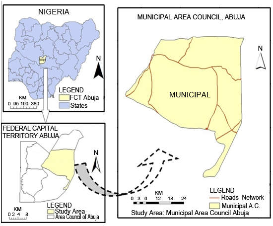
Title: Evaluating suitability for sustainable urban growth of Abuja by using MCE and GIS
Author(s): Jaafar Abdullahi Shuaibu, Can Kara *
Affiliation(s):
Faculty of Architecture, Near East University, Nicosia, Cyprus

* Corresponding Author.
 Corresponding author's ORCID profile: https://orcid.org/0000-0003-2121-9442
Digital Object Identifier:
https://doi.org/10.21833/ijaas.2019.07.009
Abstract:
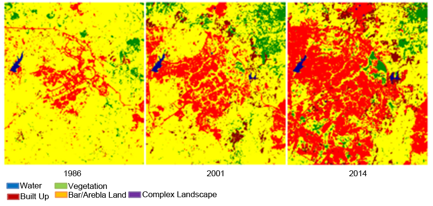
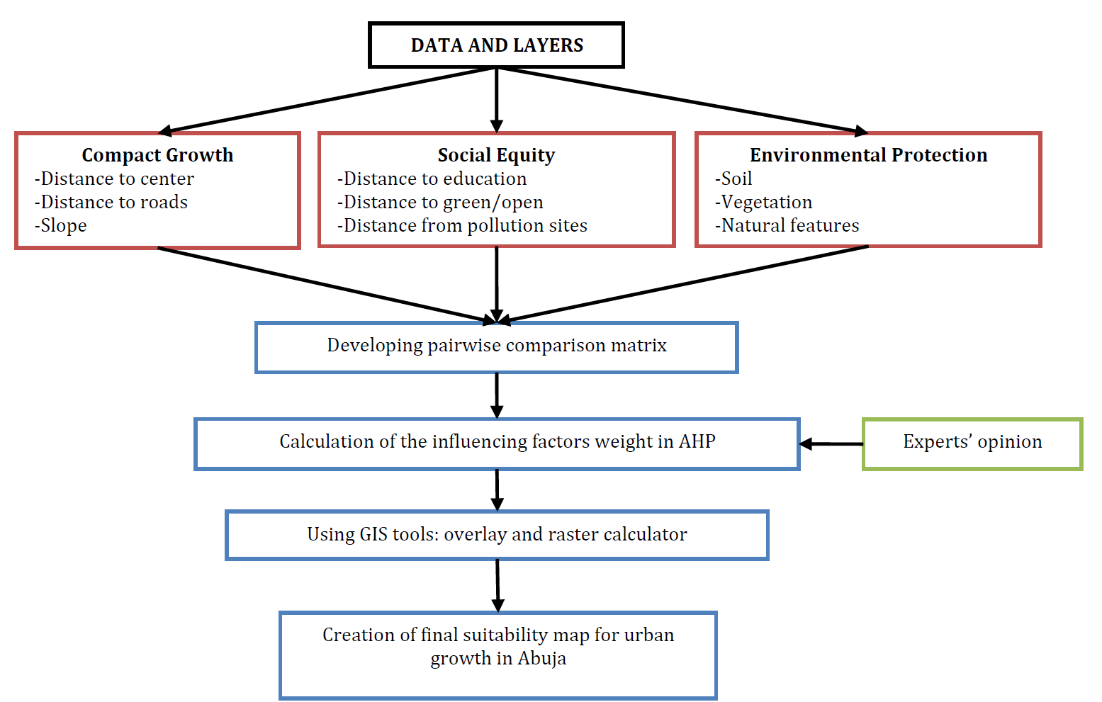
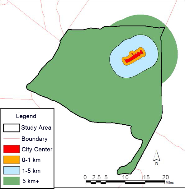
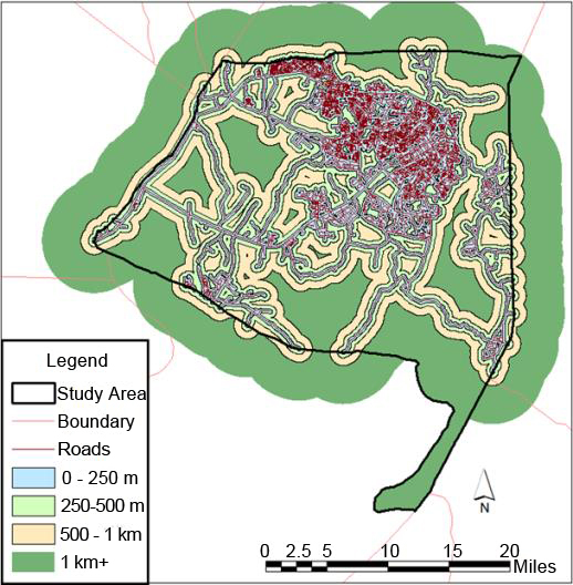
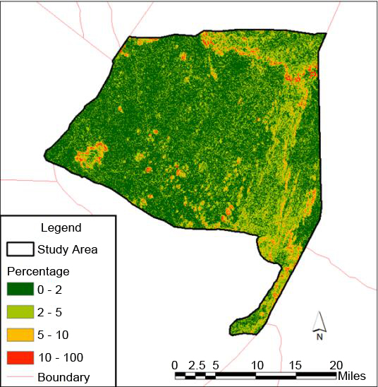
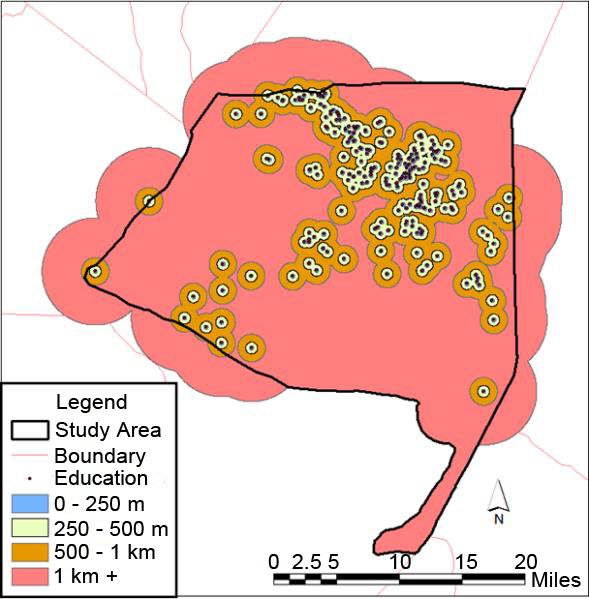
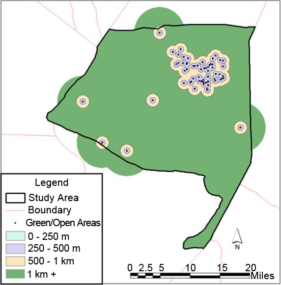
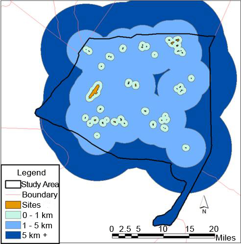
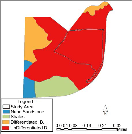
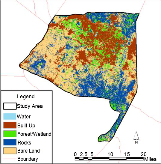
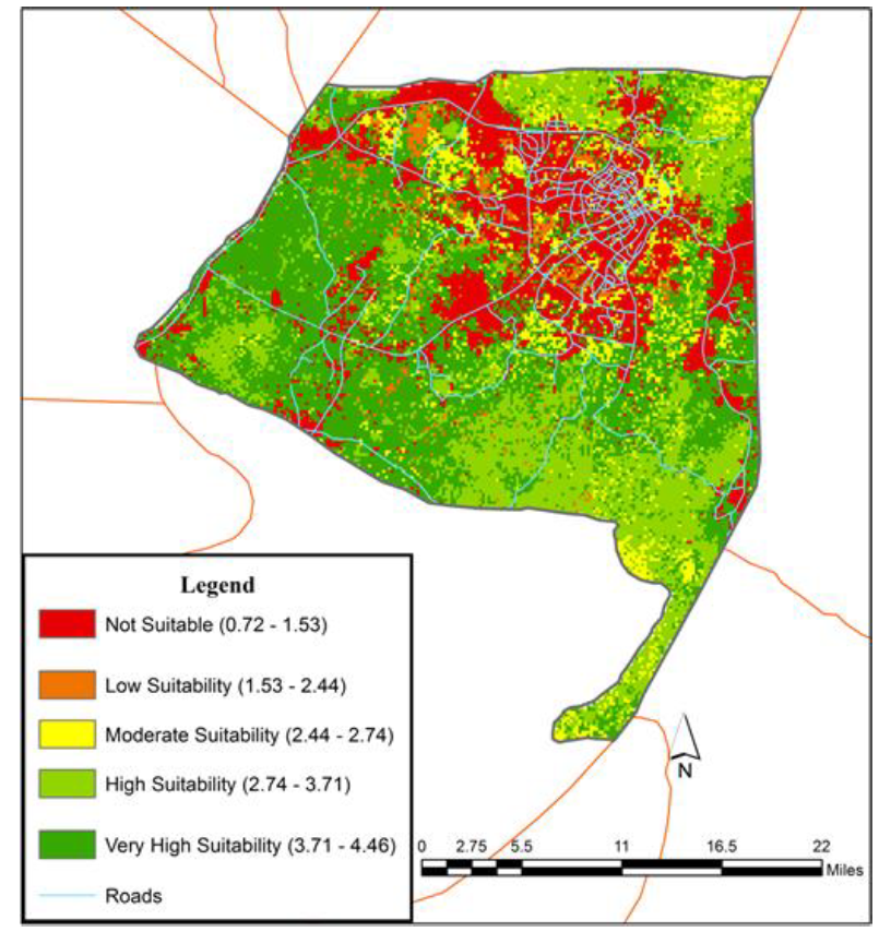
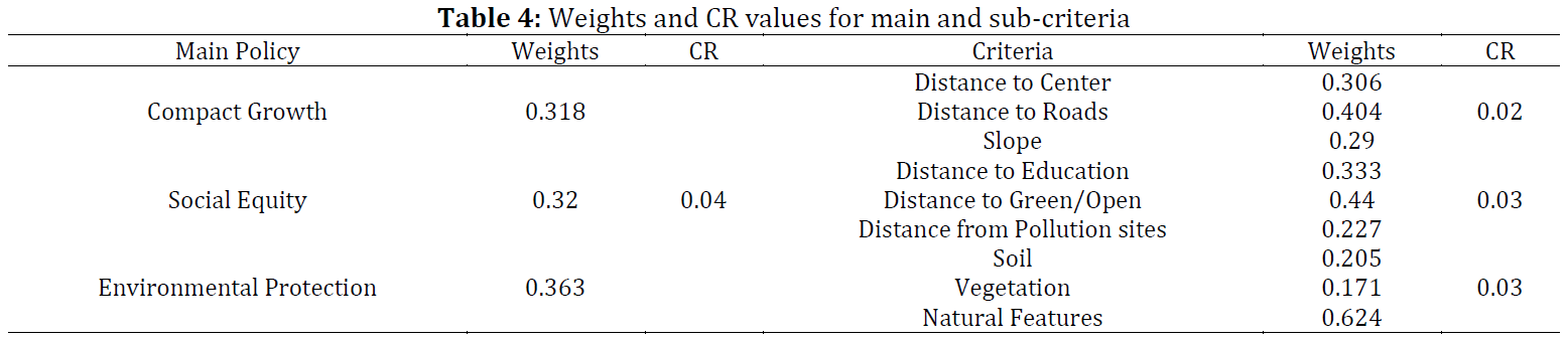
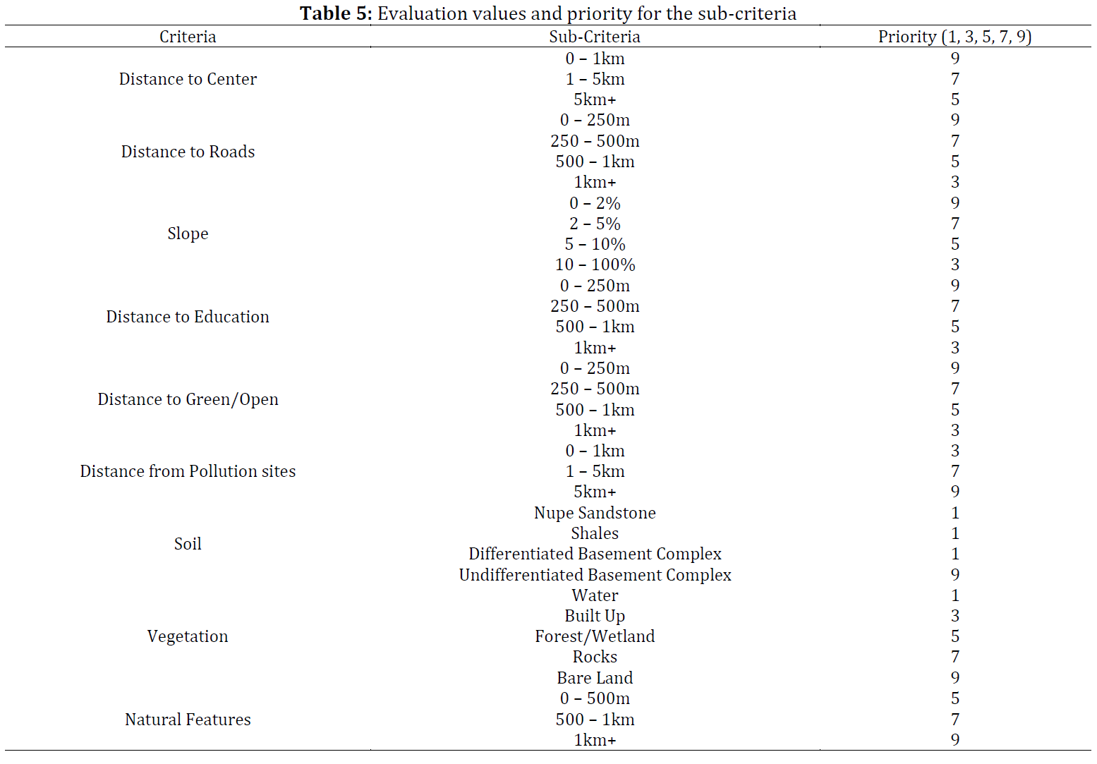
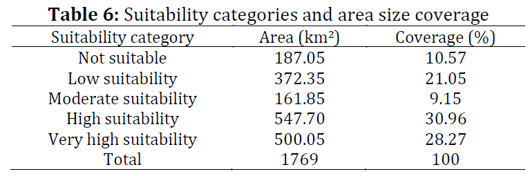
Abuja, the federal capital of Nigeria was created when Lagos failed to function as the Federal Capital due to the resultant urban problems as a result of land availability. Currently, the rate of implementation of the master plan and urban development is outpaced by the rate of urban growth due to urbanization, as a result exerting a lot of strain on the urban facilities of the city which affects the life of the residents. This study is aimed at identifying a suitable site for future sustainable urban growth in Abuja. The study evaluates urban growth policies namely; social equity, compact growth and environmental protection into spatial layers as the framework for multi-criteria evaluation using the geographical information system. The spatial layers are the distance to road, distance to the central area, distance to educational facilities, distance to green/open spaces, soil, slope, vegetation, natural features, and pollution sites were evaluated and prioritized as per judgment of relevant experts. The influencing weights among the layers were computed using Analytical Hierarchy Process. The overall Consistency Ratio (CR) of the module was 0.04 and fulfilled the tolerable threshold (i.e., CR ≤ 0.1). The Weighted Linear Combination (WLC) function of ArcGIS model builder has been applied to generate a suitability map. The map clearly presents the areas that are suitable for future sustainable urban development and also areas that are not, reducing the possibility of future disaster.
© 2019 The Authors. Published by IASE.
This is an
Keywords: Abuja, Geographical information systems, Multi criteria evaluation, Sustainable urban growth, Analytical hierarchy process, Land suitability
Article History: Received 13 November 2018, Received in revised form 5 April 2019, Accepted 9 May 2019
Acknowledgement:
The authors would like to take this opportunity to acknowledge each and every person that contributed in one way or the other towards this research. We appreciate all your assistance and we are deeply grateful.
Compliance with ethical standards
Conflict of interest: The authors declare that they have no conflict of interest.
Citation:
Shuaibu JA and Kara C (2019). Evaluating suitability for sustainable urban growth of Abuja by using MCE and GIS. International Journal of Advanced and Applied Sciences, 6(7): 68-76
Figures
Fig. 1 Fig. 2 Fig. 3 Fig. 4 Fig. 5 Fig. 6 Fig. 7 Fig. 8 Fig. 9 Fig. 10 Fig. 11 Fig. 12 Fig. 13 Fig. 14
Tables
Table 1 Table 2 Table 3 Table 4 Table 5 Table 6
----------------------------------------------
References (33)
- Aburas MM, Abdullah SH, Ramli MF, and Asha’ari ZH (2017). Land suitability analysis of urban growth in Seremban Malaysia, using GIS based analytical hierarchy process. Procedia Engineering, 198: 1128-1136. https://doi.org/10.1016/j.proeng.2017.07.155 [Google Scholar]
- AbuSada J and Thawaba S (2011). Multi criteria analysis for locating sustainable suburban centers: A case study from Ramallah Governorate, Palestine. Cities, 28(5): 381-393. https://doi.org/10.1016/j.cities.2011.05.001 [Google Scholar]
- APA (2002). Policy guide on smart growth. American Planning Association, Washington D.C., USA. Available online at: https://bit.ly/2VtWDH6
- Asgarian A, Soffianian A, Pourmanafi S, and Bagheri M (2018). Evaluating the spatial effectiveness of alternative urban growth scenarios in protecting cropland resources: A case of mixed agricultural-urbanized landscape in central Iran. Sustainable Cities and Society, 43: 197-207. https://doi.org/10.1016/j.scs.2018.07.023 [Google Scholar]
- Carver SJ (1991). Integrating multi-criteria evaluation with geographical information systems. International Journal of Geographical Information System, 5(3): 321-339. https://doi.org/10.1080/02693799108927858 [Google Scholar]
- Chandio IA, Matori AN, Yusof K, Talpur MAH, Aminu M (2014). GIS-basedland suitability analysis of sustainable hillside development. Procedia Engineering, 77: 87-94. https://doi.org/10.1016/j.proeng.2014.07.009 [Google Scholar]
- Eastman JR (1999). Multi-criteria evaluation and GIS. Geographical İnformation Systems, 1(1): 493-502. [Google Scholar]
- EC (1999). European spatial development perspective. European Commission, Brussels, Belgium. Available online at: https://bit.ly/30g22k6
- EC (2003). Towards a local sustainable profile. European Common Indicators. European Commission, Brussels, Belgium. Available online at: https://bit.ly/2Hg9vrK
- EEA (1995). Europe's environment: The Dobris assessment. European Environment Agency, Copenhagen, Denmark. Available online at: https://bit.ly/2Hg8WOE
- FCDA (2018). Geography of Abuja. Federal Capital Development Authority, Garki, Abuja, Nigeria. Available online at: https://bit.ly/2HjCGc5
- Gbadegesin JT and Aluko BT (2010). The programme of urban renewal for sustainable urban development in Nigeria: Issues and challenges. Pakistan Journal of Social Sciences, 7(3): 244-253. https://doi.org/10.3923/pjssci.2010.244.253 [Google Scholar]
- Javadian M, Shamskooshki H, and Momeni M (2011). Application of sustainable urban development in environmental suitability analysis of educational land use by using AHP and GIS in Tehran. Procedia Engineering, 21: 72-80. https://doi.org/10.1016/j.proeng.2011.11.1989 [Google Scholar]
- Jepson EJ (2001). Sustainability and planning: Diverse concepts and close associations. Journal of Planning Literature, 15(4): 499-510. https://doi.org/10.1177/088541220101500401 [Google Scholar]
- Jibril IU (2010). The return of the greens in Abuja, Nigeria’s new capital city. In the International Federation of Surveyors (FIG) Congress, Sydney, Australia: 11-16. [Google Scholar]
- Kara C (2013). Simulating sustainable urban growth by using GIS and MCE based CA: The case of Famagusta, North Cyprus. Ph.D. Dissertation, Eastern Mediterranean University Gazimagusa, North Cyprus. [Google Scholar]
- Long Y, Mao Q, and Dang A (2009). Beijing urban development model: Urban growth analysis and simulation. Tsinghua Science and Technology, 6(14): 782-794. https://doi.org/10.1016/S1007-0214(09)70149-X [Google Scholar]
- Mahmoud IM, Duker A, Conrad C, Thiel M, and Shaba Ahmad H (2016). Analysis of settlement expansion and urban growth modelling using geoinformation for assessing potential impacts of urbanization on climate in Abuja City, Nigeria. Remote Sensing, 8(3): 220-229. https://doi.org/10.3390/rs8030220 [Google Scholar]
- Marull J, Pino J, Mallarach JM, and Cordobilla MJ (2007). A land suitability index for strategic environmental assessment in metropolitan areas. Landscape and Urban Planning, 81(3): 200-212. https://doi.org/10.1016/j.landurbplan.2006.11.005 [Google Scholar]
- NCGIA (2005). Land suitability analysis-user guide for ArcView 3.x and ArcGIS 9.x. NC Division oF Coastal Management, NC Center for Geographic Information and Analysis. Available online at: https://bit.ly/2JF7B5o
- Nijkamp P and Perrels A (2014). Sustainable cities in Europe. Routledge, Abingdon, UK. https://doi.org/10.4324/9781315070513 [Google Scholar]
- Okoye C (2013). Developing sustainable cities: Abuja as a case study. In the American Sociological Association (ASA) 2013 Annual Meeting Paper, New York, USA. [Google Scholar]
- Park S, Jeon S, Kim S, and Choi C (2011). Prediction and comparison of urban growth by land suitability index mapping using GIS and RS in South Korea. Landscape and Urban Planning 99(2): 104-114. https://doi.org/10.1016/j.landurbplan.2010.09.001 [Google Scholar]
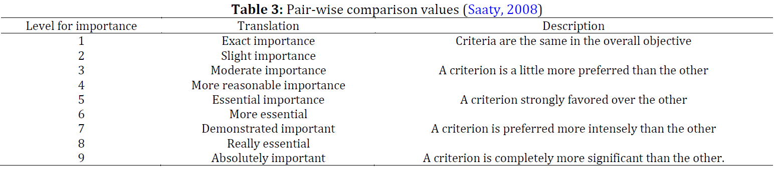
- Saaty TL (2008). Decision making with the analytic hierarchy process. International Journal of Services Sciences, 1(1): 83-98. https://doi.org/10.1504/IJSSCI.2008.017590 [Google Scholar]
- Sorensen A (2000). Land readjustment and metropolitan growth: An examination of suburban land development and urban sprawl in the Tokyo metropolitan area. Progress in Planning, 53(4): 217-330. https://doi.org/10.1016/S0305-9006(00)00002-7 [Google Scholar]
- Steiner F, McSherry L, and Cohen J (2000). Land suitability analysis for the upper Gila River watershed. Landscape and Urban Planning, 50(4): 199-214. https://doi.org/10.1016/S0169-2046(00)00093-1 [Google Scholar]
- Temiz N and Tecim V (2009). The use of GIS and multi-criteria decision-making as a decision tool in forestry. OR Insight, 22(2): 105-123. https://doi.org/10.1057/ori.2008.8 [Google Scholar]
- UN (2015). Sustainable urban development in Africa. United Nations, New York, USA. Available online at: https://bit.ly/2HgHeBv
- UN (2016). Towards an Africa urban agenda. United Nations, New York, USA. Available online at: https://bit.ly/2YuFGcX
- Usman L and Lay U (2013).The dynamics of land cover change in Abuja City, Federal Capital Territory, Nigeria. Journal of Environmental Studies and Sciences, 8(special): 14-24. [Google Scholar]
- Vaz NE, Nijkamp P, Painho M, and Caetano M (2012). A multi-scenario forecast of urban change: A study on urban growth in the Algarve. Landscape and Urban Planning, 104(2): 201-211. https://doi.org/10.1016/j.landurbplan.2011.10.007 [Google Scholar]
- Weldu WG and Deribew IA (2016). Identification of potential sites for housing development using GIS based multi criteria evaluation in Dire Dawa city, Ethiopia. International Journal of Science: Basic and Applied Research, 28(3): 34-49. [Google Scholar]
- Wu F (1998). SimLand: a prototype to simulate land conversion through the integrated GIS and CA with AHP-derived transition rules. International Journal of Geographical Information Science 12(1): 63-82. https://doi.org/10.1080/136588198242012 [Google Scholar]