
International
ADVANCED AND APPLIED SCIENCES
EISSN: 2313-3724, Print ISSN:2313-626X
Frequency: 12
![]()
Volume 6, Issue 6 (June 2019), Pages: 70-77

----------------------------------------------
Original Research Paper
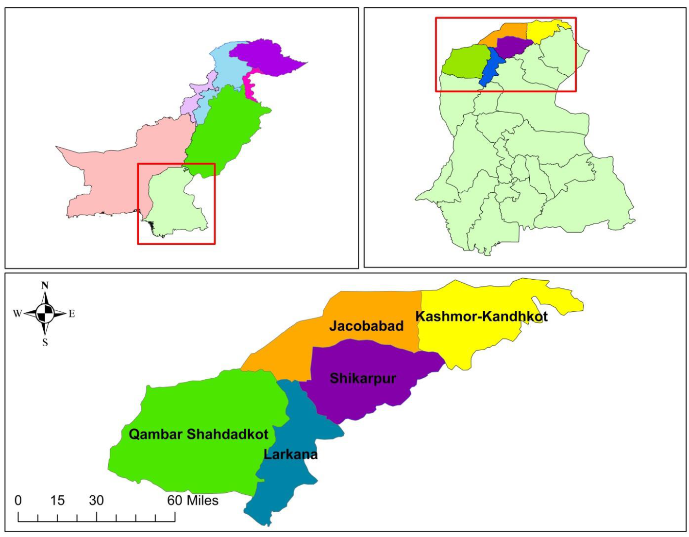
Title: Economic damages of rice crop due to flood 2010 and its mitigations in Larkana division using geo-spatial tools
Author(s): Aftab Ahmed 1, *, Muhammad Arfan 1, Hafiz Usama Imad 2, Ashfaque Ahmed Pathan 3, Arif Asghar 4, Muhammad Halar Zaman 1
Affiliation(s):
1United States Pakistan Centre for Advanced Studies in Water, Mehran University of Engineering and Technology, Jamshoro, Sindh, Pakistan
2Department of Civil Engineering, ISRA University, Hyderabad, Sindh, Pakistan
3Department of Civil Engineering, Mehran University of Engineering and Technology, Jamshoro, Sindh, Pakistan
4Department of Civil Engineering, Quaid-E-Awam University of Engineering, Science and Technology, Nawabshah, Sindh, Pakistan

* Corresponding Author.
 Corresponding author's ORCID profile: https://orcid.org/0000-0003-3463-9227
Digital Object Identifier:
https://doi.org/10.21833/ijaas.2019.06.011
Abstract:
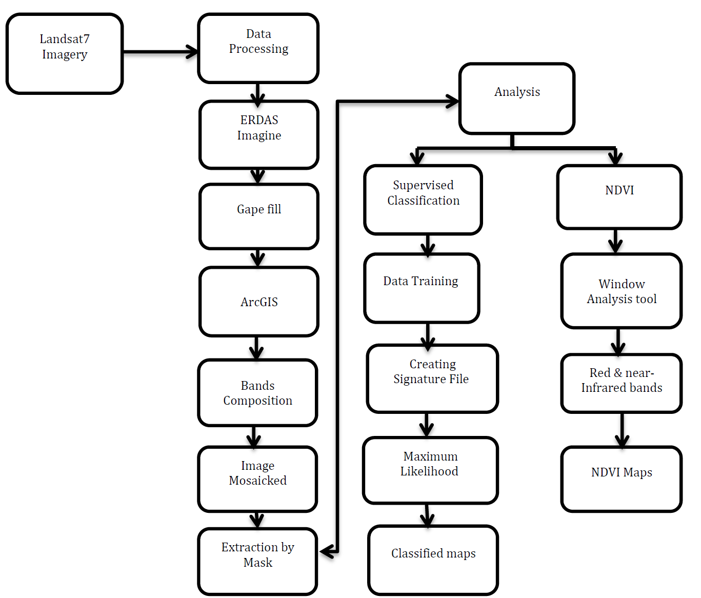
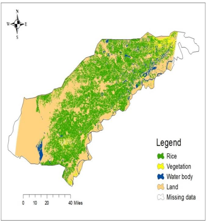
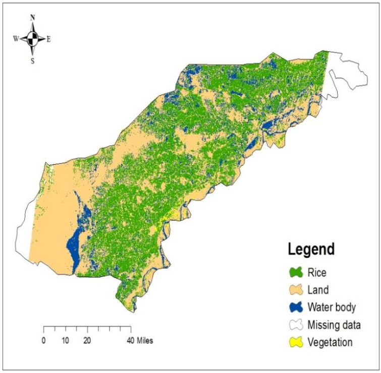
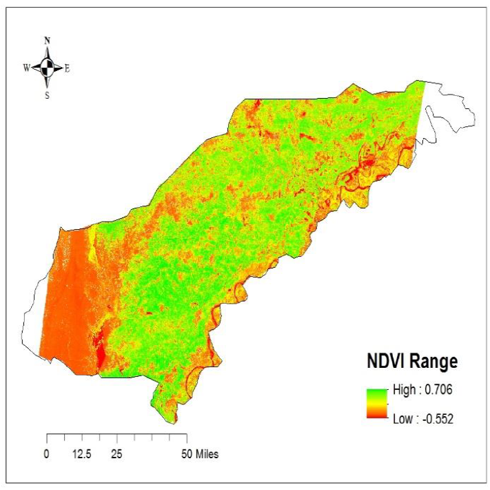
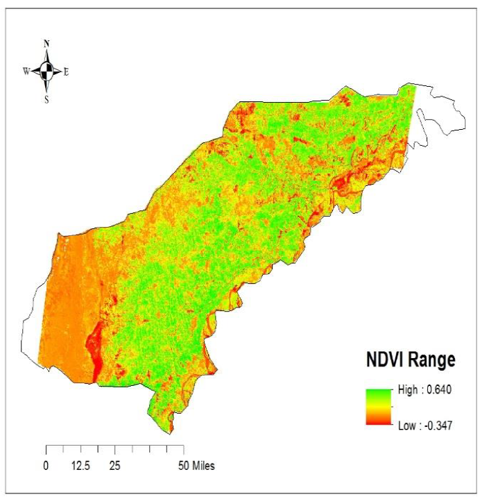
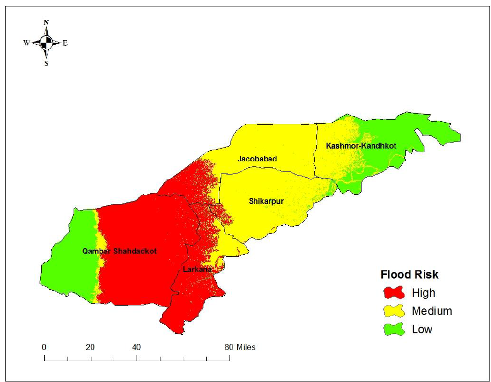
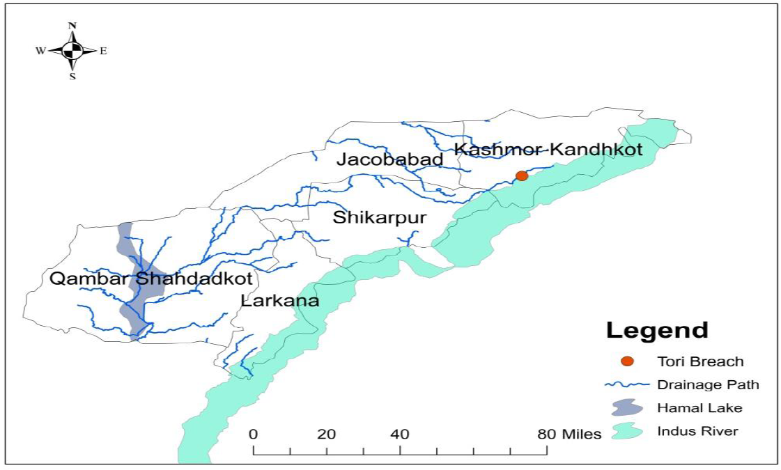
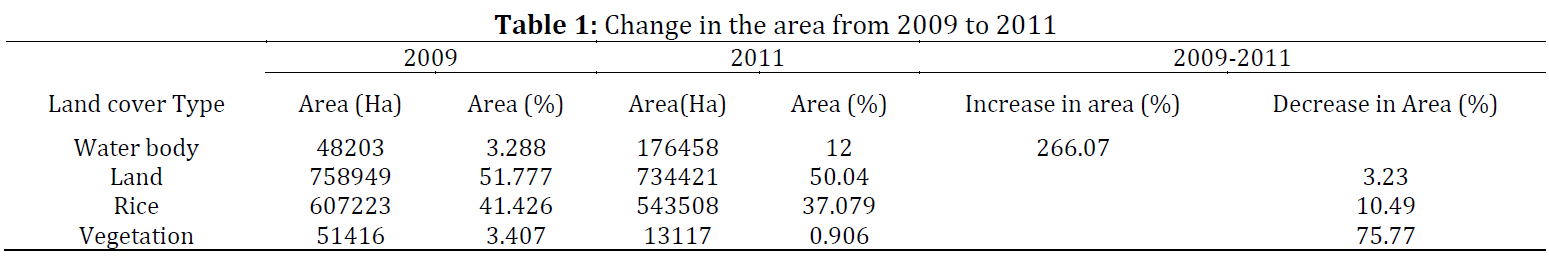
This study was conducted to assess the crop damages due to flood and to develop flood risk maps in order to mitigate its future damages. For that purpose, field and satellite data was used to assess economic damages of Rice crop, prepare flood risk maps and to delineate possible flow paths for safe disposal of flood runoff in case of any future breach on the right side of the Indus river. For the current study, Landsat data for the years 2009 and 2011 along with ASTER Digital Elevation Model (DEM) were analyzed with ArcGIS 10.3, and ERDAS IMAGINE. The results of the study showed that about 247973.024 tons rice of worth 11.425 billion Pakistani rupees was damaged due to flood 2010 in Larkana Division. Moreover, the created flood risk map showed that most of the area of Larkana and Qamber-Shahdadkot has low elevation. Therefore, the risk of floods to these areas is high, while the Kashmore-Kandhkot district has a comparatively high altitude. Thus, the risk of flood is low in that district. The most prolonged flood flow path delineated from DEM using geospatial tools shows that the flow path starts from the southern part of Kashmore-Kandhkot, and then it enters Shikarpur and eventually disposes-off into Hamal Lake in Qamber-Shahdadkot which could be used for safe disposal in future flood scenarios to moderate the flood damages.
© 2019 The Authors. Published by IASE.
This is an
Keywords: Feasible flow path, Flood risk mapping, Crop damages, GIS and remote sensing data
Article History: Received 17 December 2018, Received in revised form 20 March 2019, Accepted 10 April 2019
Acknowledgement:
We would like to thank the U.S-Pakistan Center for Advanced Studies in Water (US-PCASW), Mehran University of Engineering and Technology (MUET), Jamshoro Sindh, Pakistan for support and providing a platform for conducting this research. We would also like to thank NASA and Sindh irrigation department for providing helpful data. Efforts of Engr. Muhammad Akram Akhund and Dr. Rick Berite are also acknowledged who helped to improve quality of this manuscript.
Compliance with ethical standards
Conflict of interest: The authors declare that they have no conflict of interest.
Citation:
Ahmed A, Arfan M, and Imad HU et al. (2019). Economic damages of rice crop due to flood 2010 and its mitigations in Larkana division using geo-spatial tools. International Journal of Advanced and Applied Sciences, 6(6): 70-77
Figures
Fig. 1 Fig. 2 Fig. 3 Fig. 4 Fig. 5 Fig. 6 Fig. 7 Fig. 8
Tables
----------------------------------------------
References (20)
- Arambepola NMSI and Lglesias G (2009). Effective strategies for urban flood risk management. In the Economic and Social Commission for Asia and the Pacific Expert Group Meeting on Innovative Strategies towards Flood Resilient Cities in Asia-Pacific, Asian Disaster Preparedness Center, Bangkok, Thailand: 21-23. [Google Scholar]
- Borga M, Anagnostou EN, Blöschl G, and Creutin JD (2011). Flash flood forecasting, warning and risk management: The HYDRATE project. Environmental Science and Policy, 14(7): 834-844. https://doi.org/10.1016/j.envsci.2011.05.017 [Google Scholar]
- Clark MJ (1998). Putting water in its place: A perspective on GIS in hydrology and water management. Hydrological Processes, 12(6): 823-834. https://doi.org/10.1002/(SICI)1099-1085(199805)12:6<823::AID-HYP656>3.3.CO;2-Q [Google Scholar]
- Coppin P, Lambin E, Jonckheere I, and Muys B (2002). Digital change detection methods in natural ecosystem monitoring: A review. In the Series in Remote Sensing-Proceedings of the First International Workshop on the Analysis of Multi-Temporal Remote Sensing Images-Multitemp, World Scientific; London, UK, 2: 3-36. https://doi.org/10.1142/9789812777249_0001 [Google Scholar]
- Coppock JT (1995). GIS and natural hazards: An overview from a GIS perspective. In: Carrara A and Guzzetti F (Eds.), Geographical information systems in assessing natural hazards: 21-34. Springer, Dordrecht, Netherlands. https://doi.org/10.1007/978-94-015-8404-3_2 [Google Scholar]
- Dinh Q, Balica S, Popescu I, and Jonoski A (2012). Climate change impact on flood hazard, vulnerability and risk of the Long Xuyen Quadrangle in the Mekong Delta. International Journal of River Basin Management, 10(1): 103-120. https://doi.org/10.1080/15715124.2012.663383 [Google Scholar]
- Haq M, Akhtar M, Muhammad S, Paras S, and Rahmatullah J (2012). Techniques of remote sensing and GIS for flood monitoring and damage assessment: A case study of Sindh province, Pakistan. The Egyptian Journal of Remote Sensing and Space Science, 15(2): 135-141. https://doi.org/10.1016/j.ejrs.2012.07.002 [Google Scholar]
- Hausmann P and Weber M (1988). Possible contributions of hydroinformatics to risk analysis in insurance. In the 2nd International Conference on Hydroinformatics, Zurich, Switzerland: 9-13. [Google Scholar]
- Isma'il M and Saanyol IO (2013). Application of remote sensing (RS) and geographic information systems (GIS) in flood vulnerability mapping: Case study of River Kaduna. International Journal of Geomatics and Geosciences, 3(3): 618-627. [Google Scholar]
- Malloy P, Takenouchi S, Kim HS, Lu Y, and Ferrell B (2018). Providing palliative care education: Showcasing efforts of Asian nurses. Asia-Pacific Journal of Oncology Nursing, 5(1): 15-20. [Google Scholar]
- Mohammad I, Habib A, Abdur R, Abdur R, Naveed A, and Ikarmullah K (2006). Weeds and medicinal plants of Shawar valley, District Swat. Pakistan Journal of Weed Science Research, 12(1/2): 83-88. [Google Scholar]
- Mustafa D (1998). Structural causes of vulnerability to flood hazard in Pakistan. Economic Geography, 74(3): 289-305. https://doi.org/10.2307/144378 [Google Scholar]
- Rahman A (2010). Disaster risk management: Flood perspective. OmniScriptum Publishing Company, Saarbrücken, Germany. [Google Scholar]
- Rehman A, Jingdong L, Du Y, Khatoon R, Wagan SA, and Nisar SK (2016). Flood disaster in Pakistan and its impact on agriculture growth (a review). Environment and Development Economics, 6(23): 39-42. [Google Scholar]
- Sambah AB and Miura F (2016). Spatial data analysis and remote sensing for observing tsunami-inundated areas. International Journal of Remote Sensing, 37(9): 2047-2065. https://doi.org/10.1080/01431161.2015.1136450 [Google Scholar]
- Sardar MS, Tahir MA, and Zafar MI (2008). Poverty in riverine areas: Vulnerabilities, social gaps and flood damages. Pakistan Journal of Life and Social Science, 6(1): 25-31. [Google Scholar]
- Smith LC (1997). Satellite remote sensing of river inundation area, stage, and discharge: A review. Hydrological Processes, 11(10): 1427-1439. https://doi.org/10.1002/(SICI)1099-1085(199708)11:10<1427::AID-HYP473>3.3.CO;2-J [Google Scholar]
- Tarboton DG (1997). A new method for the determination of flow directions and upslope areas in grid digital elevation models. Water Resources Research, 33(2): 309-319. https://doi.org/10.1029/96WR03137 [Google Scholar]
- Uddin K, Gurung DR, Giriraj A, and Shrestha B (2013). Application of remote sensing and GIS for flood hazard management: A case study from Sindh Province, Pakistan. American Journal of Geographic Information System, 2(1): 1-5. [Google Scholar]
- Wang J, Rich PM, Price KP, and Kettle WD (2004). Relations between NDVI and tree productivity in the central great plains. International Journal of Remote Sensing, 25(16): 3127-3138. https://doi.org/10.1080/0143116032000160499 [Google Scholar]